Gran Canaria (Las Palmas, Gando)

Back to Country
ICAO Code GCLP/LPA
Last Validated
City Gran Canaria
Position 27°55'49"N 015°23'05"W
Runway(s) 03L/21R, 03R/21L
Elevation 77 ft

General

Gran Canaria Airport located on the coast of the island from which it takes its name, is the gateway for the millions of tourists who visit the island every year. The airport is situated 25 kilometres from one of the main tourist centres of the Canary Islands - the southern area of Gran Canaria - and 18 kilometres from the island's capital and the province of Las Palmas de Gran Canaria. Thanks to its ideal weather conditions, Gran Canaria Airport has excellent operating conditions and is open 24 hours a day every day of the year. In 2006 a total of 10,286,635 passengers, 114,938 flights and 38,361 tonnes of cargo were handled. The airport of Gran Canaria is also known as BA Gando, the Spanish Air Force base who have F/A-18A Hornets and C212 Aviocars at their disposal.

Layout

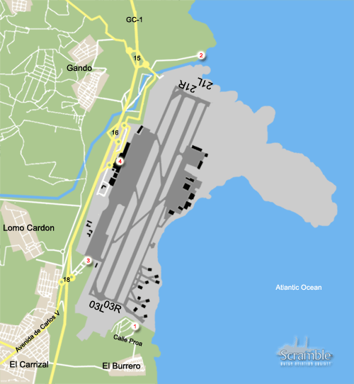
Next to the GC-1, on the west side, are the passenger terminals. The runways are north-south orientated. On the other side is the military area, with the entrance next to the GC-1 at the north side of the airport. This area is off limits.

Getting There

Arriving at Gran Canaria is mostly by plane, so you know the airport already. The airport can be accessed from the southern area of the island and from the capital by the GC-1 main road. This motorway crosses the Gran Canaria island from north to south in the east. There are also access signs to said motorway from adjoining secondary roads. From the GC-1 follow the signs to the main terminal or our routes to the spots.

Around the Airport

1Landing 03

To reach the spot 1 at the westside of Gando, take Junction 18, Carrizal at the GC-1 Southbound. At the roundabout straight ahead. Further on you see the gasstation (CEPSA/Elf) at the left hand. From here you can an overview of the HAS-area and westside of the field. Light is very hard to take pics here, as it is in your face, but also the distance is too far away. For reaching the 03R approach follow this way to next roundabout, go left, further on again left at the next roundabout, passing the motorway. After a few kilometers you are reaching the small village El Burrero. Take a street left, (most are one-way streets), at the end right, straight ahead untill you reached the small beach. Follow the road which leads you to a carpark (lefthand) and further to a small flat-building, close to the airfield/western approach. Follow the road Calle Proa up-hill and you see the HAS-area when passing the small flat-building. The approach is unrestricted as is the view onto the taxi tracks and civil aprons.

2Landing 21

The southerly landings can be spotted from a small beach at the north side. Take exit 15 from the GC-1 towards the airport and BA Gando main gate. After the roundabout(s) take the first left towards the coast towards a small fishery town. Take a right before the turn to the north and position yourself. Best for photography in the afternoon.

3Cross View

Best vantage point for a/c taxiing and landing/taking off is at the parking area at rear of the CEPSA/ELF garage on the west of the motorway junction just south of the airport. From here it is straightforward looking over the HAS area and the F-18 serials are readable with a low powered scope. From here if you travel to the roundabout by the motorway junction and turn left, at 9 o'clock is a small road. Take this and immediately turn right and follow a small road running parallel to the runway towards the airport. Along here you can read off stuff on the military ramps. With a super pole it would be possible in the evenings possibly to read off the F-27's in the hangar as the heathaze subside. With a 20x scope you could see the serials but not read them.

4Inside the Terminal

And as always, you can have a view from inside the terminal. All the civil aircraft are parked on the west side, but you will also have a view of the military aircraft at the other side.

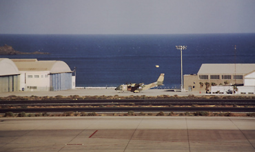
This photo is taken from spot 4 and inside the terminal. Photo Maurits Even.

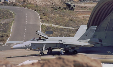
Drive south around the airport to have a similar view as on this photo. Photo Maurits Even.

Frequencies

121.700Ground
118.30/125.000/257.800Tower
120.900/121.300Approach
124.300/362.300Approach
118.600ATIS

Based Operators

Civil Operators
Binter CanariasATR72, Beech 1900D, B737
Calima AviaciónB737
SerAirBeech 1900
Military operators
Ala 46/462 EscF/A-18A
802 EscAS332B, F27-200MAR

Preserved

A.9-048/464-48SF-5A as 'C.9-048/46-48', at roundabout in military area, visible from terminal
C.10B-79/462-79HA200D on pole, visible from spot 1.
E.16-107/463-21T-6G as 'C.6-107/463-21' near military gate entrance.
T.12B-54/46-37C212 near the 'V' of Avenida Carlos V on the map

More Info

Gran Canaria AirportOfficial site for the Gran Canaria airport

Other Airfields

Fuerteventura
Gran Canaria (Las Palmas, Gando)  
Lanzarote (Arrecife)  

Send Updates

Do you have updates? Or is something not listed correctly? Please let us know! You can help us and other spotters with your information.
Invalid Input
Invalid Input

0/255

Invalid Input
Invalid Input

Subscribe to Scramble

As a member you get access to all our
premium content and benefits learn more