Opa-locka Executive

Back to Country
ICAO Code KOPF/OPF
Last Validated Oct 2009
City Opa-locka, FL
Position 25°54'27"N 080°16'41"W
Runway(s) 09L/27R, 09R/27L, 12/30
Elevation 8 ft

General

Like so many airports in the area, Opa-locka is a former military training base. In fact it is still partly a military base, as Coast Guard Air Station Miami is operating from Opa-locka. The remnants of the training history is especially visible from the runway layout - the base used to have more than ten runways - and the old hangars near the coast guard. Only three runways remain in use.
Apart from the Coast Guard, most flying activity is from corporate jets and props. Opa-locka is not a very busy airport and therefore not really worth spending time to wait for something to happen. But there is a lot happening on the ground. Maintenance is performed here on propliners and older jetliners. But most of all, there are several companies specialising in spares recovery of withdrawn aircraft, after which they are reduced to piles of aluminium. So there are many aircraft stored at Opa-locka, in various stages of being broken up.

Layout

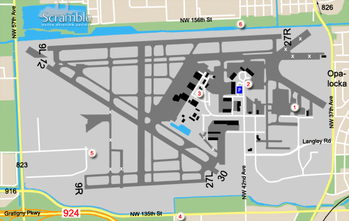
The layout of the runways is nearly the same as for Miami International: two parallel east-west runways, with a single diagonal runway 12/30. All hangars and aprons are on the eastern side of the airport, in between the parallel runways. Aircraft storage is mainly confined to the northeast corner, which is also where aircraft scrapping takes place. The US Coast Guard is located at the western edge of the hangar areas.

Getting There

Opa-locka is just south of highway 826, the Palmetto Expressway. This leads west and south to Miami International Airport, and east to Interstate 95. Take exit 37th Avenue and head south. Then you will pass the east entrance of the airport.
There is no public transportation to the airport, some Metrobusses will bring you within walking distance. Consult the Metro-Dade Transit website for details.

Around the Airport

1Aircraft scrapping area

Via the easy anti-clockwise tour of the facilities you start in the northeastern corner with the aircraft scrapping area. The former runways are used for storing aircraft until they are ready to start flying again or to be reduced to aluminium cans. All is done in the open air and there is only a small administrative building. Therefore identification of the aircraft is an easy job from the abandoned aprons west of the building, unless aircraft are parked in front of each other or nose on. However, photo opportunities are limited due to the fences and equipment.

2FBOs

Close to the main FBO the large propliners like DC-6s/DC-7s are parked. They can be photographed through the fence, in particular during the afternoon, when the sun is in the right position. A camera with a small lens diameter is advised, unless you want to get caught by security staff for attempting to climb over the fence using stairs...
Next drive around, take every possible road to get in between hangars to try to identify parked aircraft. At some location you may be able to make a snapshot through the fence, though beware of security staff.

3Coast Guard

The US Coast Guard facilities are southwest of the spot 3 marker. However the gate is already close to where Wright Road turns north to Hoxey Road which prevents you from getting close enough to see any aircraft. These are behind the buildings.
Driving top the north of this area gives you a chance to look at the large western apron (although that is often pretty empty) and view the center ramp from a different angle.

4South side

For reading off Coast Guard aircraft, you need to get off the airport. A suitable location is at the parking area of a business at the corner of NW 135th Street and NW 47th Avenue.

5West side

This spot is an alternative for spot 4. It is at the parking lot of a company built on former airport property.

6North side

Although spots 1 through 5 will enable you to obtain a nearly 100% score, the north side could result in the last unidentified aircraft being read. Beware that this residential area is not the best of the Miami area.

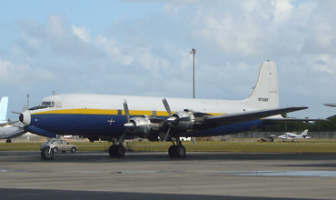
From spot 2 you can usually take a photo of the Douglas quad props parked here. The one shown above was taken with a small diameter lens through the fence. About 150 mm was enough for this photo by Leo Hoogerbrugge.

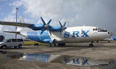
This An-12 was parked close to spot 1 and was taken through the fence. (Leo Hoogerbrugge)

Frequencies

119.200Clearance Delivery
121.900Opa-Locka Ground
120.700, 118.600Opa-Locka Tower
128.600Miami Departure/Approach
125.900ATIS

Based Operators

Boyington AviationDC-3
Florida Air CargoDC-3
Florida Air TransportDC-4, DC-6, DC-7
Legendary AirlinersDC-7
Miami City FlightCe402
TMF AircraftBeech 18, C-117

More Info

Opa-locka ExecutiveOfficial website

Other Airfields

Boca Raton  
Fort Lauderdale - Executive  
Fort Lauderdale - Hollywood
Kendall - Tamiami Executive  
Kissimmee - Gateway  
Miami - International
Opa-locka Executive  
Orlando - Executive  
Orlando - International  
Orlando - Sanford Intl  
Patrick AFB  
Tyndall AFB
West Palm Beach - Palm Beach Intl  

Send Updates

Do you have updates? Or is something not listed correctly? Please let us know! You can help us and other spotters with your information.
Invalid Input
Invalid Input

0/255

Invalid Input
Invalid Input

Subscribe to Scramble

As a member you get access to all our
premium content and benefits learn more