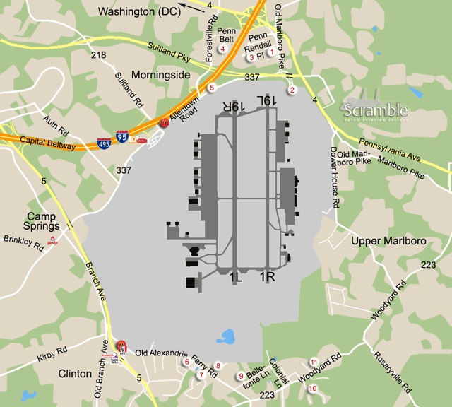
1Old Marlboro Pike
Old Marlboro Pike is signposted on highway 4 when coming from Washington (DC), it will be the first exit after the junction with the I95/I495. If there is a parking spot that you can stay at, this gives views and good lighting on approaches from the north in the morning. However, buildings, wires and trees make photography here very difficult.
2North Gate
From this disused gate, it is often possible to read some KC-135s. It has to be reached via highway 337, the Suitland Parkway. Coming from Washington, take the second exit after the junction with the I95/I495 (Suitland Pwy signposted) and then first right again. From Old Marlboro, drive north and enter highway 4 to the right, then take the first exit again.
3Penn Randall Place
This business area lies under both approaches, so it may not be the ideal standpoint but it does get you close to aircraft on final. Penn Randall Place is accessed from Old Marlboro just south of highway 4.
4Penn Belt Place
Another business area along the Interstate, opposite spot 2. Side roads of Forestville Road are called Penn Belt Drive and Penn Belt Place and are suitable for spotting and photography. The light gets better in the afternoon and a 300mm lens will do. Forestville Road is reached from the previous via the Suitland Parkway (337) towards Washington. Turn right at the traffic lights after underpassing the I95.
5U-Haul / The Classics
The parking lot on Allentown Road of the former The Classics night club next to U-Haul of Andrews AFB, if still accessible, is good for viewing/photographing 19R traffic and will do for 19L spotting too. Acting low profile is difficult here. To get here from spot 4, return via Forestville Road, cross the Suitland Parkway and overpass the I(4)95. At the T junction where you reach the base perimeter fence (and not earlier) turn left onto Allentown Road, signposted as Highway 337 north.
6Alexandra Ferry Business Park
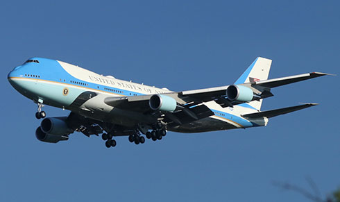
This spot along the Old Alexandra Ferry Road is most useful for evening shots of runway 1L landings for two reasons. Firstly, the light is better the later it gets. Secondly, being in a small business area you would draw too much attention during office hours, but after that it is fine. Bigger planes like the VC-25s and C-32s are fantastic here, but C-12s and the odd F-16 are too small unless you have a mega lens - which again is not advisable at such spots around this particular base.
To get here from spot 5, take Allentown Road to the southwest (base at your left) and then join Highway 5 southbound. Take the second exit for Coventry Way east and Andrews AFB. At the T junction turn right, again following the signs to the base. After a bit over half a mile, the business area starts.
7Chart Building
A bit closer to the 1L centreline than spot 6 and potentially safer as it is slightly easier to keep a low profile here. From spot 6, continue east on Old Alexandia Ferry Road and enter the business area at your right, just before Highland Meadows Drive. Drive around the building, the front side of it being used as a church, and park near Genesis Driving School next to Highland Meadows Drive. Although not ideal due to a building on the opposite side and cables, trees et cetera on your left, very decent shots of landing aircraft can be made here. Runway 1R traffic is not an option here.
8Poplar Hill Lane
An alternative to spot 7. Not very suitable for photography as it is too close to the centreline of 1L and there are too many cables, trees et cetera, but fantastic for numbers plus it is relatively easy to maintain a low profile here. Approaches on 1R can only be seen if they come in steeply, like F-16s after an overhead break. From the previous spot, take the first right on Old Alexandria Ferry Road, still driving eastbound. Opposite number 7617 is a muddy improvised parking lot, mostly used by the friendly Mexican employees of the car shop across the street. This is the spot to log some air traffic.
9Bellefonte Place
Continuing down Old Alexandria Ferry Road from the previous spots, the first left will be Bellefonte Road. From that, the first left again is Bellefonte Place, ending in a turnaround circle with the entrance to a Prime Storage facility. Parking should be no problem here and the storage does not get much traffic so it is fairly easy to stand undisturbed for a little while. Landing traffic for 1L is low here but nearly overhead; traffic for 1R is largely behind trees. This spot is therefore good for numbers of approaches to 1L but not really for photography.
From here, you can also observe helicopter traffic inbound for the western taxiway but you need a big scope for that. The helos usually approach from the northwest, from Anacosta-Bolling, the White House or elsewhere in DC and with northerly winds turn in tightly for the taxiway.
10Hunter Drive
Where Fawn Court branches off Hunter Drive you have a nice, almost unobstructed but distant view on 1L approaches, which is generally not easy here due to elevation differences, trees, buildings et cetera. The view on 1R approaches should even be better. Despite being a residential area it is very quiet here. If you show to the locals that you are 'harmless', i.e. exit the car and engage in casual activity like eating something or talk on your cellphone, you should be able to stand here in peace at least for a little while. The distance to rwy 1L is an issue with smaller planes, but the heavies are doable and you get them nicely side-on.
From the previous spots, at the end of Old Alexandria Ferry Road turn left onto Woodyard Road, Highway 223. On a side note, you will pass Eddie's Pizzas and Subs here and the latter are to be recommended - with a side of Pink Floyd while eating or awaiting your order, if you are lucky. On Woodyard Road, turn right after passing the Camp Springs Community Church to enter Hunter Drive. From spots 1-3 or directly from Washington, the easiest route leads via Pennsylvania Avenue, Highway 4 southbound. Exit this for Woodyard Road, just outside our map on the right. After 2.3 miles, there is a sharp bend to the left; take the turn-off to the right here to stay on Woodyard Road. Hunter Drive is then on the left after another 0.9 miles.
11Lolly Lane
This is a hit or miss spot for early morning recoveries of the local F-16s using runway 1R. In case they turn in tightly after breaking overhead, this is a nice and quiet place for 'over-wing' photos. Usually the first one of a two- or four-ship turns in tight enough, but sometimes they go wide or straight in and you do not see them altogether, as they disappear behind the trees. The spot is reached via Clendinnen Drive, which is the first left on Woodyard Road when coming from spot 10, or to the right case after passing the Restoration Worship Temple when coming from the other side.


