Belo Horizonte - Pampulha/C.D. de Andrade

Back to Country
ICAO Code SBBH/PLU
Last Validated Oct 2006
City Belo Horizonte, MG
Position 19°51'04"S 043°57'02"W
Runway(s) 13/31
Elevation 2589 ft

General

Pampulha airport is in the middle of Belo Horizonte, it used to be the major international airport of Belo Horizonte. Nowadays, the main air traffic for the capitol of Minas Gerais is handled by Tancredo Neves Int'l / Confins. That airport is situated about 30 km north of town though.

Layout

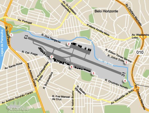
The passengers terminal is situated on the south side of the airfield. West of that, the military ramp and hangars can be found. The south east is occupied by a large row of hangars and aprons. Lastly, the north side has a general aviation ramp and some hangars as well.

Getting There

Pampulha airport is in the south east of the similarly named suburb. It is just to the east of Pampulha lake at the spot were Antonio Carlos highway becomes Dom Pedro I. Alternatively, follow MG-010 highway north and take the exit to the airport. Highway 010 actually runs all the way to Tancredo Neves as well.

Around the Airport

1West side approach runway 13

Between the dual carriage way Dom Pedro I and the airport perimeter there is a piece of barren land. You can probably not leave your car there for long, so park south of Rua Coronel Fraga and walk towards the threshold from there. Alternatively, find a spot on the other side of the bank of the Lagoa de Pampulha.

2North side view, hangar road

After passing the threshold of runway 13 on Dom Pedro I, take the exit at the corner of the airfield. Keep to your left at the fork in the road, the first right is the Rua Dos Hangares. You will now enter airport terrain. From this road, that works its way to the northern ramps, you can see part of the military ramp on the south side and the north side ramp as well.

3North east side threshold view, Rua Josue Sotte

Still on the north side, head east crossing the Ona river and go right into the residential area. Keep to your right until you get onto Rua Josue Sotte. This runs parallel the runway and airfield perimeter wall. From here you can have a look at the runway, albeit from the north.

4East side view runway 31

To get here from spot 3, take the road running parallel and to the north of Josue Sotte. This is Rua Edson Tomas Santos. Enter the Avenida Cristiano Machado and head south. When the rail road running along the centre line of the highway, bends to the east, take the exit onto Sebastião Brito. Immediately go right into Orozimbo Nonato. From there go right on the small asphalt road. From this spot, or the soccer pitch, you will have a good view of the runway 31 approach.

5South east side view

Follow Orozimbo Nonato, cross the roundabout and go straight on. Make a right at the next cross roads. You will now be to the east of the eastern most hangar on the south side. The runway can be seen from this spot, this around the touchdown point for runway 31, provided you bring steps.

6South side hangars and ramps

From spot 5, go back to the roundabout and make a left. Continue until you reach a through road with separated ways. This will be Sebastião Brito again and is the fifth to the right. Go right and follow this road past the cemetery. Go right onto Isabel Bueno. This road bends left, keep following it until you reach a junction with a small park in the middle. Go right and right again onto the road that runs behind the hangars. You can have several peeks between the hangars and see some parts of the ramps. This is airport terrain obviously.

7Terminal view

From the terminal the airliners parked in front can be seen.

Frequencies

121.600Ground
118.100Belo Horizonte tower
120.200 / 129.100Belo Horizonte approach
129.400 / 119.650Belo Horizonte approach
121.100Belo Horizonte traffic
127.450ATIS

Based Operators

Civil operators
Air MinasEMB120RT(disbanded?)
Banjet Taxi AéreoBeech 300, EMB121A,
Ce550, Hawker 800A
CBM Taxi AereoCe550
Líder Taxi AéreoBeech C90A/B200,
Beech 400A,
Bell 206L4,
Bell 212/412SP,
Ce525, Hawker 800,
Lj35A, PC-12/45,
S-76A/C, S-92
Taxi Aéreo Minas Gerais (TAMIG)Ce402C, IAI1124
Total Linhas AereasATR-42-500,
ATR-72-200/500,
B727-200F, EMB120ER
Military operators
Centro de Instrução e Adaptação da AeronáuticaC-95, T-25C, U-42

More Info

Order of battle

Other Airfields

Anápolis
Barbacena - Maj.Bgd.Doorgal Borges
Belo Horizonte - Pampulha/C.D. de Andrade  
Brasilia - Pres.Juscelino Kubitschek Intl
Campo Grande
Canoas
Curitiba-Bacacheri  
Dos Afonsos - Campo delio Jardim de Mattos  
Florianópolis - Hercilio Luz  
Fortaleza - Pinto Martins Intl  
Guaratinguetá
Ilha do Terrapleno de Leste
Ladário - Base Fluvial
Lagoa Santa  
Pirassununga - Campo Fontenelle  
Rio de Janeiro-Galeão/Antônio Carlos Jobim Intl  
Rio de Janeiro-Santos Dumont/Jóia Rara
Salvador-Deputado Luis Eduardo Magelhaes
Santa Cruz-Bartolomeu de Gusmão
Santos
São José dos Campos-Prof Urbano Ernesto Stumpf  
São Paulo - Congonhas  
São Paulo - Guarulhos/Gov. André Franco Mororo
São Paulo-Marte
São Pedro da Aldeia  
Taubaté-Base de Aviação
Vilhena  

Send Updates

Do you have updates? Or is something not listed correctly? Please let us know! You can help us and other spotters with your information.
Invalid Input
Invalid Input

0/255

Invalid Input
Invalid Input

Subscribe to Scramble

As a member you get access to all our
premium content and benefits learn more