Campo Grande

Back to Country
ICAO Code SBCG/CGR
Last Validated Aug 2006
City Campo Grande, MS
Position 20°28'07"S 054°40'21"W
Runway(s) 06/24
Elevation 1833 ft

General

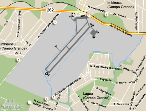
The city of Campo Grande hugs the airport where both military and civil aircraft can be found. The field is very open and offers good opportunities to watch the activities.

Layout

There is a civil terminal to the north west of the runway. The military apron is on the opposite side, the north east.

Getting There

The airfield is in the south west outskirts of the city well north of the PRF ring road and just south of BR-262. In the map above, we did not depict all roads obviously. Especially the east side needs to be navigated with a bit of common sense.

Around the Airport

1North east side approach 24

Take Av. Pres. Vargas off BR-262 and make a left onto Av. Taquari. At the point were this road becomes Florianopolis you can enter a patch of sand. From there you have an excellent view of the approaching aircraft to runway 24.

2North west side ramp view

Continuing on BR-262 to the civil terminal will bring you past the threshold. From here you must be able to see the FAB ramp. However this is a busy dual carriage way and therefore hard to stop at. Go to the civil terminal itself. To the north east of it, near the access to the perimeter road, you should be able to see the civil and military ramps from the grass along the fence.

3West side ramp and runway view

After leaving the civil terminal make a left onto BR-262, and left again to Av. Wilson Paes de Barros. This leads along the perimeter fence and you will have a residential area to your right. When the undergrowth on the base allows, good views can be had of both the runway and FAB ramp.

4South west side approach 06

Continuing on Wilson Paes will bring you to the end of the residential area. The road is unpaved and leads into the barren lands. From this spot you can watch the landing aircraft at runway 06. You will have back light most of the day however. By following the sand paths counter clockwise through the farmland, you will reach the tree lined farm and thus spot 7, which see.

5South side approach 06

The airfield is hugged by many barrios and small patches of rough woodland, streams, and ditches on the east side. However, if you can find your way through the myriad of roads to the western side of this urban area, you can reach the 06 approach from the south east side as well.

Best bet will be to take Av. Tiradentes off BR-262, the first right on the large roundabout upon entering the city when coming from the airport; 20°27'59.79"S, 54°38'13.55"W). Follow this southward 2 km until you come to Melvim Jones, a street forking of to the right. Cross the water, the road is now named Petropolis. Make a left after the roundabout at the church into Paulo Hideo Katayama. After 1 km, you reach a T-junction, go right and you will arrive at the perimeter. You can spot the aircraft that approach runway 06.

6South side approach 06 (2)

There is another place from where the approach can be viewed. Alas, a stream blocks your path. But by following the road, R. Cel. Athos P. da Silveira, that runs westward along the perimeter you will cross it. Make a right towards the fence again. From here, a farm, or fazienda as they call it in Brazil, blocks your view a bit. You can see the threshold from behind and you will see the approaching aircraft albeit a bit high. It is unclear if, and how far, you can wander into the farm land here.

7South side approach 06 (3)

There is yet another spot in this maze. Go south west from the corner described at spot 6. Go right towards a tree-lined Fazienda. From here you can enter the farmland again. Alternatively, go past the farm and make a right into a sand path. This eventually leads to the other side of the approach and the path described at spot 4.

Frequencies

121.900Ground
118.100Tower
120.200Approach
122.500Operations

Based Operators

Civil operators
Amapil Taxi AereoEMB820C
GENSACe510, EMB110P1A,
EMB120RT
MS Taxi AereoEMB820C
Military operators
3°/3°GAvA-29A, A-29B,
T-27
2°/10°GAvSC-95B, SC-105,
H-1H
1°/15°GAvC-95B, C-95C,
C-105A

Other Airfields

Anápolis
Barbacena - Maj.Bgd.Doorgal Borges
Belo Horizonte - Pampulha/C.D. de Andrade  
Brasilia - Pres.Juscelino Kubitschek Intl
Campo Grande
Canoas
Curitiba-Bacacheri  
Dos Afonsos - Campo delio Jardim de Mattos  
Florianópolis - Hercilio Luz  
Fortaleza - Pinto Martins Intl  
Guaratinguetá
Ilha do Terrapleno de Leste
Ladário - Base Fluvial
Lagoa Santa  
Pirassununga - Campo Fontenelle  
Rio de Janeiro-Galeão/Antônio Carlos Jobim Intl  
Rio de Janeiro-Santos Dumont/Jóia Rara
Salvador-Deputado Luis Eduardo Magelhaes
Santa Cruz-Bartolomeu de Gusmão
Santos
São José dos Campos-Prof Urbano Ernesto Stumpf  
São Paulo - Congonhas  
São Paulo - Guarulhos/Gov. André Franco Mororo
São Paulo-Marte
São Pedro da Aldeia  
Taubaté-Base de Aviação
Vilhena  

Send Updates

Do you have updates? Or is something not listed correctly? Please let us know! You can help us and other spotters with your information.
Invalid Input
Invalid Input

0/255

Invalid Input
Invalid Input

Subscribe to Scramble

As a member you get access to all our
premium content and benefits learn more