Bangalore (Hindustan)

Back to Country
ICAO Code VOBG/
Last Validated Feb 2009
City Bangalore
Position 12°57'03"N 077°39'57"E
Runway(s) 09/27
Elevation 2914 ft

General

The former international airport of Bangalore has now been replaced by a brand new airport 40 km north of Bangalore, at Devanahalli. Hindustan Aeronautics Ltd. (HAL) has a facility here as well as National Aeronautics Ltd. (NAL).

Layout

North side

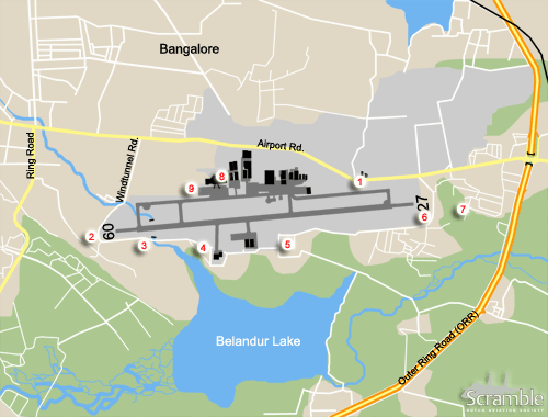
The civil terminal is on the northwest side of the airport. Its current status with the new airport open, is unclear. The HAL and NAL facilities occupy the rest of the northern side. The companies also have a large area to the north of Airport road. That part is also the location of a heliport used by HAL and the army.

South side

The south side houses the Centre for Airborne Systems in the southwest corner. They have a separate ramp with two hangars. To the east of their hangar a large HAL ramp can be found. The HAL fleet operates from there.

Alternatively, play it safe and use one of the sand tracks running west of the golf course between the Outer Ring Road and the airfield. Landing aircraft will be a bit higher though.

Getting There

The airport is situated in the southeast of the city on the north bank of Lake Belandur. It can be reached by following the Outer Ring Road (ORR) southbound. Airport road takes you along the north side of the field.

Around the Airport

1HAL Museum

The excellent and cheap HAL Museum is situated north along airport road. From the 3rd floor of the museum building, great views can be had of the runway. Although photography is prohibited, this spot is great for watching.

2Terminal

The terminal will give you a clear view of the civil airliners parked right in front of you. A view of the HAL facility that is on the south side of the runway opposite the terminal is also possible. Some aircraft can be poled off with late afternoon light.

3North side ramp view, apartment building

Just west of the terminal the residential area meets the perimeter wall. Again, a high building should be found. If you succeed in this, a great late afternoon view of the HAL ramp is the result. There used to be some unfinished apartment buildings here, it is uncertain if they are still there.

4West side approach 09, main road

Head west on airport road, take Windtunnel Road southbound on the west side of the airport. Go over the river and past the threshold. You will have the airport to your left and a golf course to your right. The road bends sharply to the left following the airport perimeter wall. The locals tend to watch aircraft here as well.

5West side approach 09, small road

This place is somewhat less conspicious than spot 4. Take the road along the southern perimeter. You will now be south of the thershold itself. Aircraft that come in to land can be seen and photographed here.

6South side CABS-DRDO area

Follow the perimeter road along the south side of the airfield. After the bridge over the stream you can drive either straight on to the CABS-DRDO site or take a sand track cutting of the corner. Along that sand track some buildings might enable you to gain some height to view over the perimeter wall onto the CABS ramp and taxi track.

7South side, HAL area

Continuing on the road along the south side of the airfield will bring you to the HAL facilities. Go past those and when the road meets the perimeter wall again, go right into the residential area. Try to find a multi storey building and scale that to gain height.

8East side approach 27, perimeter road

Just past the perimeter wall on the east side, a road runs along the eastern threshold, following the perimeter all the way around the airport. Of course, the view is great from this road. Especially were it meets the south-eastern corner of the perimeter wall. But you will be in full sight here.

9East side approach 27, village

Alternatively, do not take the perimeter road but drive slightly more east and enter the village. In the south western outskirts of this suburb, you will be a bit further from the airfield but still okay for the approach.

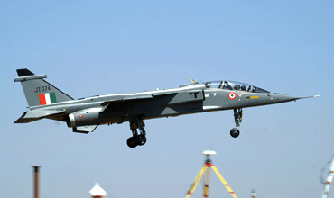
Two seat Jaguar coming in, seen from spot 5. (Fred Willemsen)

Frequencies

123.500Tower
122.700/127.700Approach
128.250ATIS

Based Operators

Defence Research & Development Organisation (DRDO)various laboratories and research facilities
Hindustan Aeronautics Ltd (HAL)
various divisionsaircraft manufacture and overhaul
Aircraft DivisionJaguar maintenance and spare parts production
Helicopter DivisionChetak and Dhruv production
Overhaul DivisionKiran and Mirage 2000 maintenance
Civil operators
Aviators IndiaBeech 1900D
GMR AviationBAe125-750
Bell 407
Falcon 2000
Taal Air CharterP68C

Preserved

various a/cat the HAL Heritage Center and Aerospace Museum
D1696Marut 1T
Inside ASTE gate and visible through that.

Other Airfields

Adampur  
Agra  
Ambala  
Bangalore (Hindustan)  
Bhatinda (Bhisiana)  
Bidar AFS  
Chandigarh  
Dundigal AFS  
Goa - Dabolim/INS Hansa  
Hakimpet AFS  
Halwara  
Hyderabad - R.Ghandi Intl / Begumpet AFS  
Jodhpur  
Pathankot  
Pune - Lohegahon / Pune AFS  
Pune - National Defence Academy gliderdrome  
Yelahanka AFS  

Send Updates

Do you have updates? Or is something not listed correctly? Please let us know! You can help us and other spotters with your information.
Invalid Input
Invalid Input

0/255

Invalid Input
Invalid Input

Subscribe to Scramble

As a member you get access to all our
premium content and benefits learn more