1Approach 18 - east side
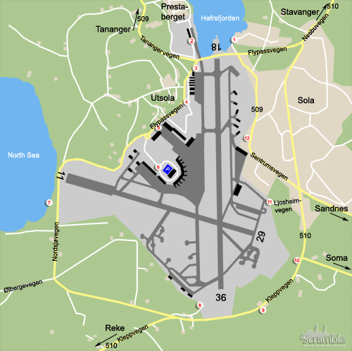
Sola has many spots to practice your hobby. We start our round tour coming from the city of Stavanger on road no.510 in the north east corner of the map. Spot 1 can not be reached from the nearest intersection, as you are unable to turn right here. Instead, take a right on Joavegen at the intersection before reaching the airfield. Turn left at the next intersection and follow the road to the left along the waterfront. A great bay view awaits you here with good photo-opportunities of approach 18 in the morning hours.
2Approach 18 - west side & museum
Continuing counterclockwise around the airfield from spot 1, continue around the bay on the road that runs parallel to the road no.510, by which you can reach the museum. The opening hours of the museum are limited to weekday-afternoons during Summer months, and during Spring and Fall to Sunday- afternoons, so plan your trip beforehand if you can. The museum is housed on the former sea plane base, and views of approach 18 are great from the this area. Photography inside the museum is allowed, and flying activity outside can best be graphed in the afternoon as well.
3Approach 18 - west side & aprons north side
Another spot to view the approach of runway 18 from the west side is spot 3. From the museum, cross the intersection and head to the airport terminal on road no.509. Right after the intersection, some space can be found on your left hand side. Its probably hard to park your car around here, but enough space exists on the other side of the road. Be careful turning here. Views of the approach are o.k. from here, as is the graphing. The general aviation aprons are located just south of this spot and most aircraft can be read from here as well, although back lit.
4Runway & taxiway - westside & aprons - south side
Stay on Flypassvegen, which doubles as road no.509 and head toward the airport terminal. After passing the last general aviation hangar, turn left at the T-junction. Again, parking will be difficult here, but views of the southern part of the general aviation area are good. Moreover, aircraft on the western taxiway and runway can be photographed from here as well, preferably in the afternoon.
5Terminal - north side & military apron - west side
Head south again, you still have not reached the terminal area. Instead, just north of it, you will find a spot on your left from which you can have a look on the northern aprons near the main terminal. If aircraft are parked here, this is probably the best spot to read them off. You may even snatch a few pics from here in the late afternoon. Be careful to have your car parked first, the other side of the road has a ample parking lots. The military helicopter hangar is situated on the other side of the runway from this spot. In the late afternoon, a little bit of sunshine will give you the right conditions to read them off, even the ones inside when the hangar is open.
6Terminal area - south side
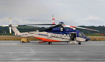
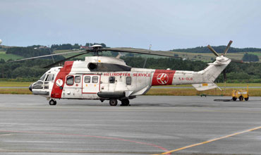
The terminal area is next on the list. It offers few possibilities, and aircraft parked right in front of the terminal, on its south-east side that is, are particularly hard to catch. The off-shore helicopters can be found to the south side of the terminal. Driving the road to the terminal, make a right exit, right after entering the loop. Between the buildings, the old terminal now is use by the off-shore helicopter companies, a parking lot can be found. Great views of the helicopters are possible from here. Although facing south, Norway's greyish climate may come handy here, as chances are you will experience overcast... in the early morning you may well have some welcome sunlight on your objects of interest.
7Approach 11 - south side
After leaving the terminal area, turn left at the roundabout to continue your loop around the airfield. The road is curvy but leads you around threshold 11, you will now drive along Sola Beach. That said, a parking spot can be found on your right, just before you reach the intersection. From here, simply walk to the beach and find yourself a great view. Just be protect your camera gear, as the beach is very windy at times. Photography is great from this spot during most of the day.
8Approach 36 - west side
Continuing to the next, just pick up the trail where you left off and drive on road no.509, which will turn eastward. Just before the intersection with road no.510, keep left on the parallel road, passing a couple of houses. At the fence, spot 8 is located, which provides you with views of approach 36 and the aprons before the hangars on your left, just east of threshold 36. Photography is best after noon.
9Approach 36 - east side
For a morning view of approach 36, coming from spot 8, head back to the intersection and continue your loop on road no.510, which means you have to turn left twice. Past threshold 36, take the first real road on your right, which is named Stangelandvegen. Turn right again heading back to the direction you came from on the parallel road, south of the main road. Just find yourself a spot here to view aircraft approaching runway 36.
10Approach 29 - south side
If runway 29 is in use, you are likely to spend much time at the next spot. From spot 9, take Stangelandvegen to your right, turn left at Sandnesvegen (so not in the Soma direction on the map). Head back to road no.510 and turn left here, where you will find a spot to park on your right, which can not be reached easily and safely by turning on road no.510 when coming from the west. Photography is good here from later in the morning.
11Military aprons - south side
The southern military aprons are next on the menu. Continue on road no.510 to Stavanger and Sola and turn left at Ljosheimvegen, just before reaching the intersection with Sentrumvegen. From this road, views of the southern aprons are scarce, and you have to be lucky something is parked here. The military helicopter hangar is hidden behind the woods and the helicopters are parked on the west side of it, refer spot 5.
12Large military apron - east side
The large triangular military apron can be seen from various spots on the east side, although good views are scarce. One option is the side road, which is actually just south of spot 12 on the map. From spot 12, the southern part of the apron can be seen. As this is the military side of the airfield, we do not recommend taking pictures here.


