Latakia - Bassel el Assad Intl

Back to Country
ICAO Code OSLK/LTK
Last Validated May 2010
City Latakia (Al Ladhiqiyah)
Position 35°24'04"N 035°56'55"E
Runway(s) 35/17
Elevation 157 ft

General

Latakia or al-Lāḏikiyya (اللَاذِقِيَّة) is an ancient coastal town. It has an international airport, which is situated 20 km south east of the city. Besides accepting international flights, the military also use it with some naval patrol helicopter squadrons.

Be aware, plane spotting is neither understood nor appreciated in the Syrian Arab Republic!

Layout

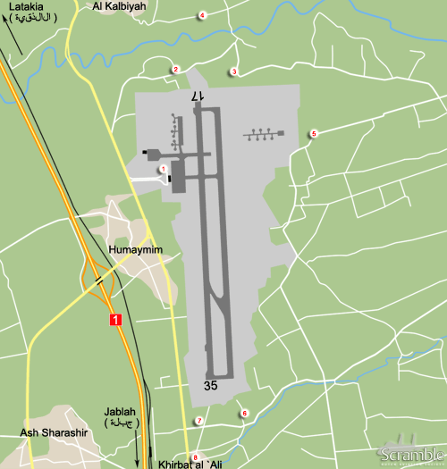
The airport currently has a single north-south runway but a parallel runway has been constructed east of that recently. It is unclear whether this will become the main runway relegating the old one to a taxiway or that it actually will be an additional runway, 17L/35R in that case.

The terminal is on the north west side and north of that a ramp and hangar of one of the helicopter units can be found. On the opposite side of the runway, in the north east corner, some dispersals are located. Most of them seem out of use, only the active ones are depicted on our map.

The airfield is on a hill surrounded by wooded and hilly terrain. Clear views of the walled-off airport are nearly impossible except from the terminal area.

Getting There

At the eastern outskirts of Latakia town, highways no.4 and 1 meet. Take highway no.1 southbound, the airport is signposted. There are two exits, one to the north and one to the south of the airport. Both work out well because there is a through road running parallel with the highway.

Around the Airport

1Terminal area

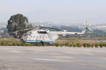
The terminal area offers peeks at the helicopter ramp. This can be done from outside the terminal, on the north side. The ramp in front of the terminal is not visible, only from air side. From the exit road, you can also see some stored Mi-14 helicopters at the edge of the ramp, serials are scrubbed away or faded though.

2North side approach - PM

About 500 metres north of the terminal exit, a road forks off to the right, go in there. Fairly quickly after the right hand bend, there is a street to your left into a small residential area. It runs circular and meets the main road again. So you can take either the first or second entry. From there you will be able to watch the approach.

3North side approach - AM

Proceed east, at the sharp bend right, make a left. You will be heading north and there is a patch of barren land on your left hand side providing a view between the trees of the approach to runway 17, and especially 17L when it becomes operational.

4North side approach alternative

By going a bit further north, pass the small stream and make a left. You will then be on a road running parallel to the one along the perimeter. Obviously, this is more distant but also quieter.

5North east side dispersals

The road meanders around the northern side of the airfield. It makes a sharp right turn, and then a left turn. You are close to the north east corner of the airfield now. But then the road starts leading away to the east. Keep right at the fork and then make a right at the cross roads (35°24'54.21"N, 35°58'29.31"E). Then you will head back, straight to the perimeter. This road is actually a bit higher than the north east side dispersal area, so you might be able to peek over the wall while approaching.

6South side approach - AM

You can navigate around the airfield clockwise, but it is probably easier to head south from the terminal to reach spots 6 and 7. From the terminal, the entry to this street is about 2.6 km south. Make a left onto this asphalt road. Take the second left into a small residential area. There is a clearing which should be okay for views of 35. If 35R materializes, you will be to far under it probably.

7South side approach - PM

Same entry as described under spot 6, but you can now take the first street or position yourself along the road just after leaving the through road past the terminal.

8South side approach alternative

Just like on the north side, you can take a road a bit further from the threshold. Simply go right into the first street after entering the road mentioned under spot 6. Where it bends back to the main road you will be further south west than spot 7.

Should you wish to go even further away, the entrance road to the railway complex might be a solution, this is on the other side of the through road.

From the civil terminal you can encounter the odd Mi-14 if you are lucky... (spot 1, 2009, Scramble archives)

Frequencies

118.100 / 121.900Tower
120.000 / 129.600Approach

Based Operators

...sqKa-27
...sqMi-8
...sqMi-14

Preserved

...5x Mi-14, rotor-less, stored,
north west side ramp
...1x Mi-14, rotor-less, stored,
north east side dispersals

Other Airfields

Ad Dumair  
Afis  
Aleppo Intl  
An Nasriyah (Jayrud)  
Damascus - Marj as Sultan North & South  
Damascus - Qabr as Sitt  
Damascus Intl
Deir Zzor  
Hama  
Jirah  
Khalkhalah  
Latakia - Bassel el Assad Intl  
Marj Ruhayyil  
Minakh  
Rasin al Aboud  
Tabqa  
Tiyas  

Send Updates

Do you have updates? Or is something not listed correctly? Please let us know! You can help us and other spotters with your information.
Invalid Input
Invalid Input

0/255

Invalid Input
Invalid Input

Subscribe to Scramble

As a member you get access to all our
premium content and benefits learn more