Denver - Centennial

Back to Country
ICAO Code /APA
Last Validated Oct 2012
City Denver
Position 39°34'13"N 104°50'58"W
Runway(s) 10/28, 17L/28R, 17R/28L
Elevation 5885 ft

General

Centennial Airport in Arapahoe County (hence the ICAO code KAPA) is the main general aviation airport for the Denver metropolitan area. It was opened in 1967. Unlike many other secondary airport, it was newly constructed then to support businesses at the Denver Technological Center (DTC), and officially known as Arapahoe County Airport. In honour of the state's official designation as the Centennial State in 1876, the airport was renamed Centennial Airport on 13 July 1984.
Centennial is one of the busiest general aviation airports in the United States, with continuous arriving and departing traffic during working days. Therefore, if you like general aviation from light props to large Gulfstreams, a couple of hours can easily be spent here and a quick visit will always yield a couple of new visitors.

Layout

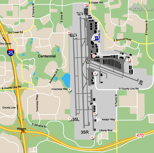
Centennial has two parallel runways running more or less north-south. The eastern runway is mostly used by visiting traffic, the western runway mainly by traffic training touch and gos. There is also a east-west crosswind runway. All businesses are on the east side of the airport, mainly in the north east corner.

Getting There

The airport is situated in the south eastern suburbs of Denver, in the north east corner of the intersection of Interstate 25 and the 470 toll road. Access is best from exit 196 of the Interstate or exit 2 of the toll road.

Around the Airport

1Denver Jet Center

Driving around the perimeter of an airport often starts at the main terminal/apron, in this case the Denver Jet Center. The parking lot in front of the terminal building provides ample space to park your car and wander around for some time. Most aircraft on the main apron can be read from the terminal building or from the fence lines, although sometimes bushes/trees may be in the way.
From the fence it is also possible to make some photos. Some aircraft may be positioned well only in the morning, some nearly all day.

2Control Tower Road

The western end of the E Control Tower Road gives you the opportunity to log aircraft not visible from spot 1.

3Key Lime Air

Key Lime Air is one of the larger companies based at Centennial. Here is the maintenance hangar and office. You can easily walk around the hangar to take photos, but to avoid someone seeing you as an unwanted person, please ask first. That also applies to other aprons around here not fenced off.

4Signature

The E Control Tower Road dead ends a few hundred meters after Key Lime Air (spot 3), so for the Signature ramp you will need to backtrack to E Bronco Parkway again, and drive around the eastern perimeter. You will pass the finals of runway 28 then, but looking at the distance to the threshold aircraft on approach will still be pretty high here.
At Signature some aircraft are parked close to the fence, making photography easy. It is best to do so in the morning, regarding the position of the sun.

5Hangars south

The last hangar area on the eastern side are easily reached from spot 4. To get the best view on the ramp, drive all the way to the end. There you can look around the hangars and see the complete apron.

6Runway 35R a.m.

At this location, there is a pullout on the west side of the road. You can park here to photograph aircraft on finals for runway 35L and 35R.

7Runway 35L p.m.

In the afternoon the parking lot of a large office building provides an alternative to spot 6. From here you should be able to photograph aircraft on finals for runways 35L and 35R, or in take-off from runway 17L or 17R (provided that they stay low). Also any aircraft not identified from spot 5 should be revealed from here.

8Inverness Reservoir Trail

As the hangars and apron of Signature are quite far from spot 7, you can go here for a closer look.

9Runway 17R p.m.

If runways 17L and 17R are used, the dead end of E Inverness Drive gives you photo opportunities in the afternoon. Also you can look on the main apron, if you have missed something.

10Scooter shop

To complete the perimeter spot 10 is suitable for making pictures of aircraft landing on runway 17L. It is the parking lot of the GreenRide Scooters.

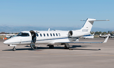
This Learjet 45 was photographed from the fence next to the Denver Jet Center (spot 1) by Leo Hoogerbrugge.

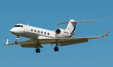
Although the aircraft are still a bit too high for really nice pictures, spot 10 is the best for action photos at Centennial. (Leo Hoogerbrugge)

Frequencies

128.600Clearance Delivery
121.800Centennial Ground
118.900Centennial Tower
132.750Denver Approach/Departure
120.300ATIS

Based Operators

Denver Air ConnectionDo328-300, EMB120, SA226/7
Key Lime AirCe404, PA-31, SA226/SA227

More Info

Centennial AirportOfficial website

Other Airfields

Denver - Centennial
Denver - International  
Denver - Rocky Mountain Metropolitan  

Send Updates

Do you have updates? Or is something not listed correctly? Please let us know! You can help us and other spotters with your information.
Invalid Input
Invalid Input

0/255

Invalid Input
Invalid Input

Subscribe to Scramble

As a member you get access to all our
premium content and benefits learn more