Moderator: gatso76
20 March 2014 Last updated at 07:23 GMT
Australia sees possible plane debris
Australia is investigating two objects seen on satellite images that could potentially be linked to the missing Malaysia Airlines plane, officials say.
Planes and ships from Australia, New Zealand and the US were heading to the area 2,500km (1,550 miles) south-west of Perth to search for the objects.
The largest appeared to be 24m in size, maritime authorities said, but warned they could be unrelated to the plane.
Australia has been searching in the southern Indian Ocean for the aircraft.
http://www.bbc.com/news/world-asia-26711298Breaking News
The following SMS message has been sent to relatives:
"Malaysia Airlines deeply regrets that we have to assume beyond any reasonable doubt that MH370 has been lost and that none of those on board survived.
As you will hear in the next hour from Malaysia's Prime Minister, we must now accept all evidence suggests the plane went down in the Southern Indian Ocean."
13:45: Australia's announcement of its discovery of debris in the ocean was also made by its head of government, Prime Minister Tony Abbott, earlier on Monday.
The search for the missing plane has become a matter of national concern for the countries involved.
Breaking News Malaysian Prime Minister Najib Razak says "with great sadness" data now confirms that the aircraft's last position was in the Indian Ocean south of Perth.
13:31: In earlier phases of the search, crews had struggled to relocate objects that were sighted by only one plane,
so the multiple sighting appears to be something of a breakthrough.
Though Australian officials stressed the objects were not yet confirmed to be from the plane.
13:28: They say Australian and New Zealand planes spotted "multiple objects of various colours" and a Chinese patrol ship will try to relocate the objects on Saturday.
13:26: At the end of the day's search, the Australian authorities announce in a statement that five planes have now spotted objects in the new search area.
12:53: A journalist on board the New Zealand plane which spotted the objects on Friday took this image of one of them:
...the rest ofApril 8, 2014 -- Updated 0522 GMT (1322 HKT)
(CNN) -- The underwater pulses that an Australian navy ship detected over the weekend have not been heard since -- but authorities are not letting that deter them in the search for missing Malaysia Airlines Flight 370.
"We have at least several days of intense actions ahead of us," Australian Defense Minister David Johnston told reporters Tuesday. "We're throwing everything at this difficult, complex task."
Investigators hope the signals could be locator beacons from the plane's data recorders, but they're not sure yet.
But buoyed by the hope that they're closing in, they reduced the size of the search area Tuesday.
Now, they are focusing on a smaller area in the Indian Ocean: 30,000 square miles (77,580 square kilometers) about 1,400 miles (2,270 kilometers) northwest of Perth. That's about a third of the size of the previous search zone.
"Instead of looking at an area the size of Texas, we're now looking in an area the size of Houston," aviation expert Geoffrey Thomas told CNN.
Time, however, is running out.
The batteries powering the beacons, which are designed to start sending signals when a plane crashes into water, last about 30 days after the devices are activated.
Experts have said it's possible that the batteries could last several days longer if they were at their full strength.
"We need to continue ... for several days right up to when the point at which there's absolutely no doubt that the pinger batteries will have expired,"
said retired Air Chief Marshal Angus Houston, the chief of the Australian agency coordinating the search.
Retired Royal Air Force Lt. Col. Michael Kay said he sees the hunt for the pingers going another week and a half.
"We know that the batteries can last up to 40 days," Kay told CNN.
"If I was Angus Houston, I would be putting the search out to at least 42, 43 (days) to make absolutely sure that the batteries had failed."
http://www.bbc.com/news/world-asia-28031741The new underwater search will initially focus on the orange area indicated
http://www.jacc.gov.au/media/releases/2 ... Search.pdf26 June 2014 Last updated at 07:18 GMT
A new search area for the missing Malaysian plane has been announced by the Australian government after further analysis of satellite data.
The search will now shift south to focus on an area 1,800km (1,100 miles) off the west coast of Australia, Deputy Prime Minister Warren Truss confirmed.
Flight MH370 vanished en route from Kuala Lumpur to Beijing on 8 March with 239 passengers on board.
Officials said they believed the plane had been on autopilot when it crashed.
A 64-page report released by the Australian government concluded that the underwater search for the plane should resume in the new area.
MH370 - Definition of Underwater Search Areas
ATSB Transport Safety Report
The underwater search for the plane was put on hold to allow more time for survey vessels to map the ocean floor.
The new search is expected to commence in August and is expected to be completed within a year , Australian Transport Safety Bureau (ATSB) chief Martin Dolan confirmed.
http://www.ibtimes.com/malaysia-airline ... er-1645582A deep-water search for signs of Malaysia Airlines Flight 370 is on track to start in September, Australian officials confirmed on Thursday.
They said that two ships tasked with mapping part of the southern Indian Ocean are continuing to make progress ahead of the mission this fall.
Since May, experts have been surveying a region of about 60,000 square kilometers (23,166 square miles) over the area where the plane is thought to have crashed in March on its way to Beijing, killing all 239 people onboard.
Experts say this area is one of the least-mapped sections of the ocean; surveys of Mars and Venus are considered 250 times more accurate, the Wall Street Journal reported.
Monday 29 September 2014 00.49 BST
Remnants of volcanoes,
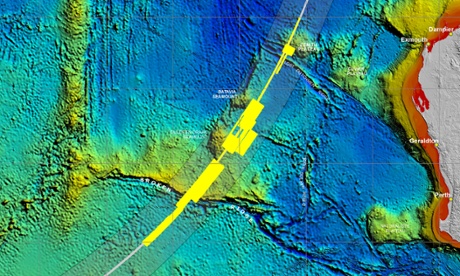
towering ridges and deep trenches have been discovered on the seabed of the southern Indian Ocean by experts
mapping the underwater terrain as part of the search for missing Malaysian Airlines flight MH370.
Australian authorities have released the three-dimensional images,
revealing for the first time details about the sea floor where efforts are being concentrated to find the jet,
which is presumed to have crashed into the sea on 8 March.
The area in which the plane is thought to have gone down is remote and largely unexplored, and officials are conducting an intensive survey of the seabed before the underwater probe for the plane can begin.
“The recently acquired high-resolution bathymetry [underwater survey] data has revealed many of these seabed features for the first time,”
the Australian Transport Safety Bureau, the agency leading the search, said in a statement.
The expanse has many of the features typically found in such areas, with tectonic movements having created now-extinct volcanoes,
rugged ridges up to 300m high and trenches 1,400m deep compared with the surrounding sea floor, the bureau said.
The bureau said identifying these features would help navigation during the underwater search phase – due to begin in October – for the Boeing 777.
Perhaps also of interest:Investigators hunting for the wreckage of Malaysia Airlines Flight 370 are set to scan the ocean floor in waters as much as 6.4 kilometres deep in the southern Indian Ocean on Sunday, amid a renewed hunt for the vanished plane.
The GO Phoenix search vessel is scheduled to arrive in its search zone on Sunday and start about 12 days of sonar surveys, the Australian Transport Safety Bureau, which is co-ordinating the operation, said in a statement on its website.
Two more ships are preparing to start work in the region as part of a year-long search.
Two more vessels contracted by the Australian government from Dutch engineering group Fugro NV will also take part in the search.
The M/V Fugro Discovery has arrived at Fremantle and is expected to join the Indian Ocean search for MH370 later this week.
The vessel had fit-out work done in Durban, South Africa, before arriving in Western Australia, and will have search equipment and a mission crew mobilised over the next few days.
The Fremantle Port Authority says the Fugro Discovery is scheduled to leave the port on Friday.
Fugro Equator is likely to be used as a search vessel when its bathymetric work finishes later this month.
http://www.ibtimes.com/mh370-indonesia- ... ts-1710846MH370: Indonesia Alerted 'Floating Debris' Of Missing Malaysia Airlines Plane May Wash Up On Its Coastline
October 23 2014
1:41 AM
Indonesia has been alerted that wreckage of missing Malaysia Airlines Flight MH370 may wash up its coastline,
media reports said.
Malaysia is optimistic that the new phase of the underwater search will locate the jetliner, which mysteriously disappeared March 8 with 239 people on board.
The Australian Transport Safety Bureau, ATSB, which is leading the search for the Boeing 777 from Perth, reportedly said that they have alerted the authorities in Indonesia about the possibility that debris of the plane may be washed up on its coastline.
It also reportedly said that they have been receiving messages from the public about having spotted objects thought to be possible debris on the Australian coastline.
Australia working on new drift modeling for MH370 wreckage
SYDNEY Tue Nov 25, 2014 11:47pm EST
Australia is working on new drift modeling to expand the geographical area in which wreckage from missing Malaysian Airlines flight MH370 may come ashore, the Australian search coordinator said on Wednesday.
Initial analysis had suggested that the first debris from the plane could come ashore on Indonesia's Western Sumatra after about 123 days.
Foley said the research center was receiving reports at least once a week of debris washed up on the Australian coastline, but none has so far been identified as coming from the missing aircraft.
http://www.atsb.gov.au/mh370.aspxGepubliceerd op 11 dec. 2014
Geoscience Australia is providing extensive advice, expertise and support to the Australian Transport Safety Bureau (ATSB).
The ATSB is leading a seabed mapping and underwater search for missing Malaysia Airlines flight 370 in the southern Indian Ocean.
Bathymetry is the study and mapping of the sea floor.
It involves obtaining measurements of the depth of the ocean and is equivalent to mapping on land.
Before the underwater search for MH370 could begin, it was necessary to accurately map the sea floor to ensure that the search is undertaken safely and effectively.
Bathymetry survey vessels spent months at sea,
scanning the sea floor with multibeam sonar to gather detailed, high-resolution data.
The data has revealed many seabed features for the first time.
This computer-animated ‘flythrough’ shows a visualisation of some of the sea floor terrain in the search area.
Joint Agency Coordination Centre
MH370 Operational Search Update - 10 December 2014
This operational report has been developed to provide regular updates on the progress of the search effort for MH370.
Our work will continue to be thorough and methodical, so sometimes weekly progress may seem slow.
Key developments this week
•Fugro Equator continues to conduct bathymetric survey operations.
•Fugro Discovery arrived back in the search area on 4 December and recommenced underwater search operations.
•GO Phoenix arrived back in the search area on 9 December and recommenced underwater search operations.
As a member you get access to all our
premium content and benefits learn more