Kiel/Holtenau

Back to Country
ICAO Code EDHK/KEL
Last Validated
City Kiel
Position 54°22'46"N 010°08'43"E
Runway(s) 08/26, 08/26 (grass)
Elevation 101 ft

General

This former German navy base, once home to the fleet of Sea Kings, is located north of the city of Kiel. When MFG5 left in November 2012, this became the civilian Airport Kiel that accomodates mostly general aviation. An interesting local operator is QinetiQ, providing aerial target services with PC-9s and PC-12s from here. During the yearly Kieler Woche (Week of Kiel), military rotorcraft tend to visit this small airport from their ships. The Kieler Woche is a major public event around a regatta, and coincides with the annual Baltops exercise. Thus, both German and foreign navy ships will be in the area, often carrying helicopters or Ospreys. The spotting conditions, both for photography and serial reading, are very scarce though.

Layout

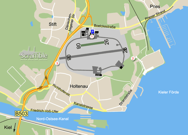
Since the closure of the heliport, the oval-like area is what the airport consists of. A taxiway runs around the east-west runway and the active facilities are in the north. Some hangars and the old control tower remain in the south, and most of the heliport infrastructure is still there in the east along the water. Parts of this are open to the public, mainly for pedestrians, but the area is to be sacrificed for urban purposes. All of the field is surrounded by roads or private property.

Getting There

The field is right along the B503, out of Kiel city to the north. Take the second exit after the Nord-Ostsee-Kanal bridge, the Boelckestraße leads directly to the entrance.

Around the Airport

1Terminal area

The central buildings here, bordering the parking lot, hold the small terminal and a restaurant. West of those, so looking right when entering the airfield, is the QinetiQ hangar. Photos of aircraft there can be made through the fence, or over it using steps. Bato's Restaurant has a very nice terrace directly along the apron, albeit with a 2m high fence. There is also a dining room on the upper floor. As a customer, spotting and photography from here are absolutely OK. When not a customer, of if you intend to use steps to take photos over the fence, do ask the staff's permission. West of the terminal is the QinetiQ hangar

2Final approach runway 26

The former taxiway that connected the MFG5 heliport with the rest of the field is now partly accessible for cyclists and pedestrians. This allows you to get south of landings on 26 (or departures from 08) at a nice short distance. To get here, it seems best to drive onto the Strandstraße south of the spot, and park near the apartment blocks where the road turns into a cycling track. From there, it is less than 1km to the spot. The other option would be to try and park at the marina just north of the centreline, but this may not be allowed. Public parking further back, towards spot 1, would put you at greater distance from spot 2 than with the southern option.

It is a bit of a hassle to get here from spot 1 by car, but the following should work. Leave the airport to the left onto the Boelckestraße. Take second left, at the traffic lights, and enter the B503 towards Kiel. Take the first exit again and where it ends, at traffic lights again, turn left onto the Richthofenstraße (they know their aces). Keep following this until it reaches the water with a 180-degree right turn. Do not follow that turn but turn left here, onto the leftmost of two streets. This is the Strandstraße, follow it as far as allowed to park.

3Final approach runway 08

On the west side, a cycling track and footpath runs right along the (high) fence, bringing you close to that runway side and the taxiway. Walking or cycling here from the airport parking lot is doable, the distance is some 1200m. For the more automotive option, start by following the directions above to spot 2. In this case, after entering the Richthofenstraße, take first left again onto the Immelmannstraße (there's another one). Park along the allotments before the street becomes a cycling track, there should be ample room for it.

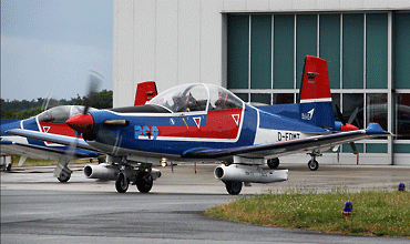
Before QinetiQ, EIS Aircraft operated the PC-9s here. Helwin Scharn photographed this pair through the fence at spot 1.

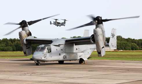
Ospreys visiting during the Kieler Woche, seen from the restaurant terrace at spot 1. (Frank Noort)

Frequencies

119.980Info
136.225Bremen Radar

Based Operators

Kiel AviationCe172, P68
QinetiQPC-9, PC-12

More Info

Airport KielOfficial site of the civil airport

Other Airfields

Ansbach/Katterbach AHP  
Berlin/Tegel - CLOSED  
Braunschweig-Wolfsburg  
Bremen/Neuenlanderfeld  
Büchel  
Bückeburg
Celle  
Coleman Barracks - CLOSED  
Diepholz  
Donauwörth Heliport  
Dresden  
Düsseldorf  
Emden
Fassberg
Frankfurt/Hahn  
Frankfurt/Main  
Fritzlar
Geilenkirchen  
Hamburg/Finkenwerder  
Hamburg/Fuhlsbüttel  
Hannover/Langenhagen  
Hohn  
Holzdorf
Illesheim AHP  
Ingolstadt/Manching  
Jever - CLOSED
Kiel/Holtenau
Köln-Bonn  
Laage (Rostock)  
Landsberg - CLOSED
Landstuhl - CLOSED
Laupheim  
Lechfeld  
Leipzig/Halle
Mendig  
Mönchengladbach (Düsseldorf)  
München/Franz Josef Strauss  
Münster-Osnabrück
Neuburg  
Niederstetten  
Nordholz  
Nörvenich
Nürnberg  
Ramstein  
Rheine/Bentlage - CLOSED  
Roth
Saarbrücken (Ensheim)  
Schleswig (Jagel)  
Spangdahlem  
Stuttgart  
Weeze
Wiesbaden AAF  
Wittmundhafen  
Wunstorf  

Send Updates

Do you have updates? Or is something not listed correctly? Please let us know! You can help us and other spotters with your information.
Invalid Input
Invalid Input

0/255

Invalid Input
Invalid Input

Subscribe to Scramble

As a member you get access to all our
premium content and benefits learn more