1Final 26 and 27
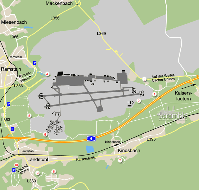
This spot is easy to reach by car and puts you below landing traffic in prevailing winds. It also offers a view on the east & south ramps of the base. From exit 14 of the A6, Kaiserslautern-Einsiedlerhof, proceed west towards Mackenbach at the roundabout and then take first left. This road is signposted as off-limits for the public but no-one usually cares about that. After about 1km the approach lights come into view and parking is possible here for a few cars. Landing traffic can be photographed from this spot although it is slightly high. Departing traffic towards the west can also be photographed when it enters the runway. One of the stored Afghan C-27s is visible from here, see spot 6 for more information.
2Threshold 26
Likely the best spot, and good for photos with western winds. At spot 1, a barrier now blocks the track into the forest, enforcing the second sign-posted traffic restriction. Park near spot 1 if able without blocking anything and walk or cycle into the woods. Turn right at the junction before the motorway underpass and then right again after some 600m, along a small creek (the Floßbach). Continue to the fence and enjoy the view; bring steps to shoot photos over the fence, at least five high to really clear it. Departures are just about good for photos too, with regard to the weeds on the mounds along the runway. There is a good view on the C-130 apron from here.
Alternatively, follow the track for about 1150m from the mentioned junction, to where it meets the fence again. Then track back along the fence, past the buildings, to where you see the runways again. Steps are needed here too for photos. The view onto the runway is somewhat better but landing traffic from the east comes into view later. For completeness: moving along the fence between the two spots, over the creek, is possible but discouraged. It involves crossing the water by hanging onto the fence in direct view of security cameras. Please don't, so we can continue enjoying these fine options.
3North-east side
This spot overlooks the eastern runway ends from a slightly elevated position. Departing and landing traffic can be seen from here but the platforms will stay out of sight. Despite facing the sun most of the day, this is not a bad spot for photos of landing aircraft from the east, since the hills of Kindsbach are in the background. Smaller planes like the C-21 will need lots of tele of course. To get here, start off like with spot 1 but follow the main road to where it bends right. Depending on the road works, parking may be possible on a wider part of the verge.
4Azur
In case of bad weather or when lacking strong binoculars, position 4 offers an alternative to view the (tails of) the large transporters on the platform. To get here, take the L356 from Ramstein to Miesenbach and Mackenbach and turn off at 'Waldparkplatz Azur', which is at right where the road bends left. From here, walk back along the road and then follow the creek. It might be obvious, but there is also a small path leading onto the fence right behind the parking lot, which might be confusing.
5Final 08 and 09
The 08 landing (and 09 should it be used) offers opportunities for photos and serials. There is no direct car access but there are several options to get here. One of them is to park at the Gedenkstätte Ramstein, the memorial for the 1988 airshow disaster. From exit 13 Ramstein-Miesenbach of the A6, follow the signs "Air Base". When turning right to enter an elevated stretch of road, you enter the old spare runway that runs straight to the West Gate. Immediately to the right is the large parking for the memorial. From there, go down the track between the trees and walk or cycle to the spot, which is about 1km from the parking lot. Alternatively, drive further towards the gate and park to the right of the roundabout, if there is room. This saves you some 200m on foot, bicycle or similar.
Another approach to spot 5 starts closer to the motorway. Opposite the exit of the A6 when coming from Kaiserlautern is a services area with large parking and the obvious facilities. This is about the same distance from the spot as the memorial parking. Along the adjacent motorway maintenance depot runs a road named after it: the Autobahnmeistereistraße. Follow this and turn left at the junction near the first shelters. If there is room, parking at the Autobahnmeisterei is also an option and saves you a few hundred meters again. Finally, parking near Hotel Atlantis along the L363 is an option too, with a forest track to follow for roughly the same distance again.
6Afghan C-27s
Four former Italian C-27s with Afghan serials were never delivered to the Afghan forces because of contract cancellation and put in storage in 2013. Three of them remain at the end of a taxiway between the shelters at the southwestern edge of the base. Depending on the season, they can be seen from this spot and partly also from the motorway or the next spots in this guide. The fourth has been moved to the hangars next to the C-130 apron. From spot 5, you get here by following the path along the fence, anti-clockwise around the base. The viewing point is just before a sharp turn to the right, after parallelling the motorway. Alternatively, you could drive from the industrial estate in Landstuhl underneath the A6 and then right to the water purifying plant, park there and walk the rest (some 800m).
7Kindsbach Lookout
After having been unuseable because vegetation had taken possession of it, this famous hillside viewing point was restored around early 2022. To get here, take the Steigstraße opposite Tex Mex restaurant Eggcited (the former Khao Thai Cuisine, ex pizzeria "Rosanna", "Massimo", "Da Francesco" and "Da Tony") and park at its end. From there, walk to the right (direction west) to the clearing with a bench, and even a stand to rest your binoculars or scope on.
8Am Herrengärtchen
As an alternative to the Kindsbach Lookout (and the only option for several years) this Aussichtspunkt right above the village of Landstuhl is another suitable place for number crunchers. That is, provided you bring something like a 60x pole (C-17s and C-5s are no problem with 30x), you can read off the aircraft parked on the platforms, and generally anything going in or out. To drive here from Landstuhl, take the L363 towards Bann. This road makes a U-turn along the hill slopes towards the base again. After that turn, exit at Zur Melkerei and drive into the village. Turn left at the first full crossing and right at the third street after that, Am Steinbruch. This leads straight to the viewing point, the last part to be walked.
9Burg Nanstein
Another remote position with a complete overview of the base. Aircraft on the ramps are readable from here too, with powerful optics. To abuse this cultural place for some good old long-distance spotting, follow the signs from the center of Landstuhl or just find your way up on the southern side of the hill that the castle is on.
10Bismarck Turm
The third remote position, to complete the log of aircraft on the ramps or for special-effect photos. With a steady hand, clear weather and a serious telephoto lens aircraft on final 08 can be captured here in a dramatic way. The centreline is at least 2 km away. In the centre of Landstuhl, find the Luitpoldstrasse with signs towards the town's Bismarck Turm. This street begins just south of the junction where the road to Kindsbach turns to the east. Follow the signs uphill to the parking lot. The tower is just a few minutes' walk from here and overlooks the base.


