Meiringen

Back to Country
ICAO Code LSMM/
Last Validated 11-2024
City Meiringen
Position 46°44'30"N 008°06'30"E
Runway(s) 10/28
Elevation 1893 ft

General

One of the best countries in the world for military aviation photography must be Switzerland. Airbases are so easily accessible, where else in the world would you have a public road crossing the runway of a military airbase and have benches on top of an aircraft shelter to enjoy the view?

Meiringen is one of the places to be when visiting Switzerland. It is located in a valley between spectacular high mountains. This valley is so deep and narrow that in the Winter period, the sun will not even reach the airbase. Keep this in mind when going there. The view from the base is breathtaking and spots to take pictures can be found everywhere around the base. There is no real base fence, and it is possible to drive over the field, but at all times stay away from places where the military would not appreciate you being around.

This airbase is definitely recommended. Tip: a trip to Meiringen is easily combined with the Axalp demonstration, which is "just around the corner". Another tip: Meiringen usually has some 8 weeks of inactivity in Summer and several blocks in Winter as well. See the More Info panel for... more info on that.

Layout

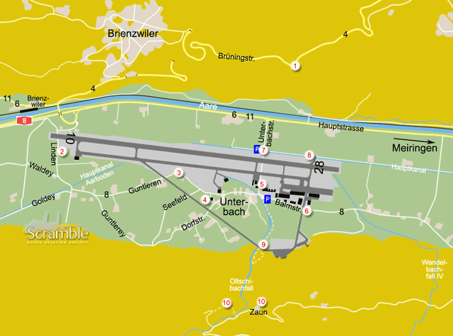
The runway is east-west, oriented like the contours of the valley. Nearly all facilities are south of its eastern end. Two taxiways connect to the caverns on the south side, crossing public roads.

Getting There

The base lies along the A8 between Lucerne (Luzern) and Interlaken, east of the Brienzersee. Coming down the mountain, which is the expressway part of the route numbered 4, you will already see the airbase in the valley. From the other side, the base lies 3.5 km past the lakeshore at Brienz (not the Brienz threatened by a landslide). From the west like Interlaken, Axalp, take exit 30 for Luzern and then the very first left to Unterbach, to arrive at the beginning of runway 10. From the north like Emmen, Luzern, Alpnach, follow Meiringen initially and then Unterbach for the same starting location.

Around the Airport

Be aware that part of the smallest roads on our map are restricted to local (motorised) traffic only. We do not show tracks here that are prohibited even for pedestrians.

1From the mountain - Brienzwiler

The expressway up on the mountain east of Brienzwiler offers a superb birds-eye view over the airfield. Most of the road is definitely no-stopping but driving the other way, you may be able to pull onto this lay-by in a left turn and enjoy the view or even take photos through the trees.

2Runway 10

After following the directions under Getting Here, cross the runway as permitted to arrive at this spot. It used to be possible to approach the runway and especially taxiway even a lot closer, but the track starting here is now off limits even for pedestrians. It is still a nice spot to hang around though and enjoy the action. When parking, be absolutely sure not to hinder farm traffic and do not enter farm land - we do not want to loose more of this spot.

3Runway 10/28

Follow the road from the previous spot, turn left after crossing the small canal and keeping left again at the next junction (road no. 8), essentially driving eastbound along the base. Where this road crosses the taxiway to the caverns, parking spots are available on that taxiway, except when it is in use during a Wiederholungskurs (WK, see operations schedule via More Info). Some 130 m further is the closest point of the road to the main taxiway and runway, making for another excellent photo location. Obviously, if the other taxiway is used that also makes for exciting close encounters with fighter jets. In that case, the nearest parking option is at spot 4.

4Shelter top

Some 350 m further down the road from spot 3 lies a shelter, not connected to a taxiway anymore. If still allowed, you can stand on top of it and have a perfect view on the runway, the main taxiway and also the taxiway to the caverns, at the back of the shelter. It is usually allowed to park here, just off the road in front of the shelter.

5Runway 28 and restaurant

Another runway crossing via public road - always a thrill for many - with several reasons to visit. Simply follow road 8 from the previous spots, or drive via spot 7 to get here, and park opposite the Restaurant Fliegertreff. This a personnel restaurant but open to the public, its opening times tied to the active hours of the military. It features a roof terrace with an excellent view over the base. On its other side, an F-5E on a pole (see Preserved panel) guards the crossing and a short service road just before the barrier offers a very nice spotting and photo location.

6East taxiway

The taxiway from the main apron to the caverns also crosses the Balmstraße so when used, this is another fine spot to give way to fighter jets crossing a country road..! For parking, see the previous spot.

7Official viewing point

Opposite spot 5, the official Besucherplatz also offers a great view on the runway, with most of the base visible behind it. If the sun is up there will be backlight obviously but there is ample parking space and it can be reached quickly from the main roads. To do so, use road no. 6 (also 11 or Haupstraße), the extension of the A8 towards Meiringen town, and turn right towards the base at the roundabout, direction Unterbach. From the parking lot, the track along the canal can be followed for some different angles.

8Runway 28 north side

Starting at the previous spot, you can walk or cycle along the water here to take position opposite the holding point for runway 28. There used to be a shelter as well to stand on, but it has been demolished. Part of the flightline is visible from here, which might yield some numbers not noted from the closer spots. If backlight is not a problem (like in Winter), this is also be a very nice photo spot, close to the runway.

9Caverns

From the road junction near spot 5, a public footpath leads along the water, the Oltschibach, towards its scenic waterfall. This path, too, crosses the taxiway to the caverns, quite close their apron, and then leads upslope. If you fancy the 10-minute walk (one way), you may be rewarded with some very interesting views at the cavern entrances and the flight line there, if the taxiway entrance is open. And at least, you will have a healthy little stroll in beautiful scenery.

10From the mountain - Zaun

A final view, or actuall two, from the edge of the spectacular cliffs south of the field. To get here, leave Unterbach towards Meiringen town via road 8, the Balmstraße. At 3.5 km from spot 6, turn right towards Zaun to start your ascent of the mountain slope. After another 5 km, blessing your power steering, you will pass a group of farm houses with a cell phone antenna behind them (house nrs. 511, 512, 514). One option to try is to the right of these houses. In that case, ask the people living here in your best German if you may park for a while to photograph the aircraft.

For the second option, take the junction to the right another 400 m further along the road. Again, park somewhere out of everyone's way near the next hairpin turn - preferably asking a local for permission. From there, a short footpath leads to the upper Oltschibachfall viewing point, also offering a unique view on the base. Very special pictures can be made from above, using a super tele.

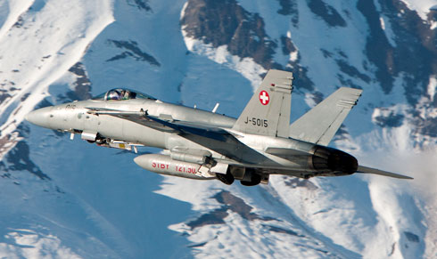
The glory of Meiringen, as shot by Michiel van Herten in early Spring, along the south side of runway 28.

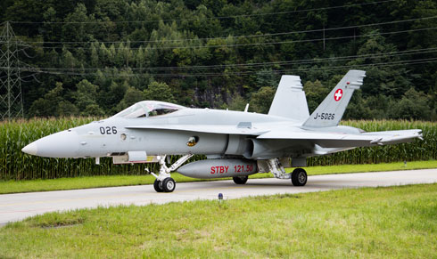
Watching the jet cross the road is what Manolito Jaarsma did at spot 6, when this Hornet was taxiing from the caverns to the rest of the base.

Frequencies

360.875 / 130.150Tower
268.625 / 138.050Info
138.275 / 142.325Arrival / Departure
143.775 / 249.800Arrival / Departure
368.450Arrival / Departure
143.200Axalp Shooting Range
138.600Ground Crew-Pilots

Based Operators

Fliegerstaffel 11F/A-18C/D

Preserved

(unknown)F-5E as 'J-3008' at spot 5

More Info

Militärflugplatz MeiringenOfficial website with operations schedule (Belegungsplan)
Target Aviation PhotographyExtensive info on photography at Meiringen
Fliegertreff RestaurantOfficial website

Order of Battle Switzerland

Switzerland - Schweizer Luftwaffe

Other Airfields

Alpnach  
Altenrhein  
Bern-Belp  
Buochs  
Dübendorf  
Ebenfluh (Axalp)  
Emmen  
Genève - Cointrin
Locarno  
Meiringen
Payerne
Samedan  
Sion  
Zürich (Kloten)

Send Updates

Do you have updates? Or is something not listed correctly? Please let us know! You can help us and other spotters with your information.
Invalid Input
Invalid Input

0/255

Invalid Input
Invalid Input

Subscribe to Scramble

As a member you get access to all our
premium content and benefits learn more