North Island NAS

Back to Country
ICAO Code KNZY/NZY
Last Validated 10-2022
City San Diego,CA
Position 32°41'54"N 117°12'48"W
Runway(s) 11/29, 18/36
Elevation 26 ft

General

Naval Air Station North Island is part of Naval Base Coronado and the staff of Commander Naval Air Forces is located here. Naval Base Coronado is also the homeport of two aircraft carriers (USS Nimitz CVN-68, USS Ronald Reagan CVN-76) which will have influence at the activities when those carriers are at home. Because it's surrounded by water, the spotting options for numbercrunchers are limited.

Getting There

The Naval Air Station is located south of San Diego on the peninsula Coronado. The maingate of the air station is reachable by leaving the I-5 (Interstate Los Angeles - Mexican-border) at exit Coronado (S-75). Continue on the S-75, which will become the 4th St. Follow the 4th St till you reach Alameda Blvd. Here the maingate is located.

Around the Airport

1Coronado Beach / Landing runway 29

Probably the best spot for taking pictures of aircraft at North Island is Coronado beach, seen here as spot 1 on the map. Landing aircraft will come in straight over the beach so it is pretty ideal to bring your girlfriend too. While she is getting a tan, you can enjoy yourself with aircraft spotting. To get here take the exit to Coronado (S-75). Follow the S-75 across the bridge and take a left at the first large crossing (Orange Ave). Continue on the Orange Ave and follow the signs 'beach' to get to the Ocean Blvd. Follow the Ocean Blvd along the beach until you are near the end of the road (and base fence). Find a parking spot and walk to the beach. At the beach walk to the right in the direction of the dog-run area. At this area you can photograph the landing aircraft perfectly, but stay away from the fence.

2Point Loma / Cabrillo Lighthouse

From the lighthouse or another spot at Point Loma you will have a good overview of the air station with San Diego city behind it. You can see the main platforms and the runways from here, but unfortunately that is it. Only with a really large scope you can make out some codes (if there are no heatwaves). Photographing of aircraft is also not really an option here or you will need at least 500+mm (digital) and a lot of cropping to get something decent. Helicopters are sometimes an option to photograph from here. How to get here is easiest to discribe from San Diego Intl Airport. When you are South of the airport near the main entrance of the airport, take the N Harbor Dr to the west. Continue this road until you arrive at a crossing where you have to go left (Rosecrans St). At Rosecrans St take the 8th street to the right (Canon St). Follow this street (which will become the Catalina Blvd followed by the Cabrillo Memorial Dr) till you reach the lighthouse. Park your car and enjoy the view. Due to security measures is the road towards this spot daily closed from 5pm till 5am.

3Shelter island / Take off runway 29

From this point it is possible to photograph some helicopters when they fly along the bay. Runway 29 departures are visible from here but to avoid Point Loma the aircraft quickly climb and turn left. If you have a good monocular (60x), you can read off codes and serials of helicopters on the platforms. This is only possible when there are no heatwaves (eg. around sunset). You can use the whole length of Shelter Island to optimize your view towards North Island. The easiest way to get to this spot is from San Diego Intl Airport. Follow the N Harbor Dr in westerly direction. Take a left at the second large crossing (Rosecrans St). At the Rosecrans St, take the 8th street to the left (Canon St)and follow this road which will become Anchorage Ln at the end till you come a crossing with Shelter Island Dr. Go right at this crossing (Shelter Island Dr) and follow this road till you arrive at Shelter Island. Along the road there is space enough to park your car.

4Harbor-tour

During a boattour in the San Diego bay you will pass by several platforms of North Island and therefore will be an ideal tour for the numbercrunchers. You will pass NADEP (maintenance) with always some Hornet present Also you will see the main SeaHawk-plaform with often a lot SH-60 and MH-60 there. If lucky you will see one or two carriers at home during this tour. The startingpoint is located along the Harbor Dr just north of the USS Midway museum. You should take the NORTH harbor-tour otherwise you will go to the wrong part of the bay. The tour will take about an hour.

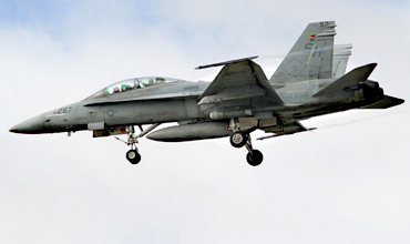
F/A-18B (164001/SH-257) taken at Spot 1. (Robert Verbrugge)

Frequencies

288.250 / 128.400Clearance Delivery
360.075 / 118.000Ground
336.400 / 340.200Tower
135.100Tower
283.000 / 317.800ATIS

Based Operators

HSC-3MH-60S
HSC-4MH-60S
HSC-6MH-60S
HSC-8MH-60S
HSC-14MH-60S
HSC-21MH-60S
HSC-23MH-60S
HSC-85MH-60S
HSM-35MH-60R, MQ-8B
HSM-41MH-60R
HSM-49MH-60R
HSM-71MH-60R
HSM-73MH-60R
HSM-75MH-60R
HSM-78MH-60R
VRC-30C-2A (FRS)
VRM-30CMV-22B
VRM-50CMV-22B (FRS)
VR-57C-40A

Other Airfields

Barstow-Daggett  
Edwards AFB  
El Centro NAF  
Fresno Yosemite Intl
Hemet - Ryan Field  
Imperial Beach NOLF
Lemoore NAS - Reeves Field  
March JARB
Miramar MCAS  
Moffett Federal Airfield
North Island NAS  
Palmdale Regional - Air Force Plant 42
Point Mugu NAS  
Sacramento - Mather
San Francisco - Intl  
Santa Monica - Municipal
Stockton Metropolitan
Travis AFB  
Van Nuys  

Send Updates

Do you have updates? Or is something not listed correctly? Please let us know! You can help us and other spotters with your information.
Invalid Input
Invalid Input

0/255

Invalid Input
Invalid Input

Subscribe to Scramble

As a member you get access to all our
premium content and benefits learn more