Stockton Metropolitan

Back to Country
ICAO Code KSCK/SCK
Last Validated 12-2022
City Stockton
Position 37°53'39"N 121°14'18"W
Runway(s) 11L/29R, 11R/29L
Elevation 33 ft

General

The Stockton Metropolitan Airport is located on the Southern boundary of the city of Stockton in the heart of California's central valley. The Airport is conveniently located between two major north-south thoroughfares; Interstate 5, 1.5 miles to the West, and State Highway 99, which borders the airport on the East side. In the months preceding World War II, the U.S. Army entered into the first of many lease agreements with the City of Stockton (on 15 August 1940) to build and operate an Army training facility at Stockton Municipal Airport. In October 1946 Stockton AAF was declared surplus. The City of Stockton and the County of San Joaquin resumed operating the Stockton Municipal Airport on 16 December 1946 under a joint license. Nowadays it has a new large terminal, many hangars for Business and general Aviation and a large apron for the California Army National Guard.

Layout

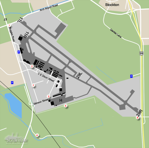
The airport has two runways and most of the aprons on the south side. The Army apron is on the southeast side.

Getting There

If you approaching from the North on Highway 99: Take the Arch Rd. exit and bear right onto Arch-Airport Rd. and follow it westbound for approximately 1 1/2 miles. Notice the airport is on your left. Just before the intersection of Arch-Airport Rd. and Airport Way you will see a left turn lane for Ruggles Frontage Rd. If you are approaching from the South on Highway 99: Take the Arch Rd. exit and follow the off-ramp westbound (left) under the highway. Once past Highway 99 the Road name changes to Arch-Airport Rd. Follow it Westbound for approximately 1 1/2 miles. Notice the airport is on your left. Just before the intersection of Arch-Airport Rd. and Airport Way you will see a left turn lane for Ruggles Frontage Rd. Turn left onto Ruggles Rd.

Around the Airport

1Landing Runway 11L/R.

On Ruggles Road, Park your car on the grass sides, and walk along Arch Airport Road towards your spot for all landing traffic on Runway 11L/R

2View onto Aprons

From spot 1, drive further on Ruggles Road, along the Terminal and take a left onto Lindbergh Street. Here you have a view onto the many aprons and hangars. You can drive around here, via C E Dixon Street to all other hangars and aprons. At the crossing of CE Dixon Street and RA Bridgefort Street, you will find the Stockton Field Aviation Museum, with some Beech 18s parked outside.

3View onto Army Apron

From spot 1, drive onto Ruggles Road, along the Terminal to the end. Take a left here onto Stimson Street. At the end of the street, at the crossing with RA Bridgeford Street, you have a view onto the US Army apron including their two preserved helicopters. Park at the Keurig Dr Pepper factory and walk to the fence if needed.

4View onto Army Apron

From spot 3, drive back towards Road J3, take a left and a next left at a small road. From here you will have another view onto the Army apron. This road is fenced off.

5View onto Army Apron

From spot 3, drive back towards the crossing with Road J3. Just before Road J3, take a left onto Airport Drive and follow it, It will turn into a gated dirt road but you can follow it along the fence giving you a very close view onto the Army Choppers, maybe too close. Park your car at the gate and walk onto Rydberg Creek to have a look at the Army apron.

6Landing Runway 29R/L

For spot 6, you have to follow the Getting There instructions onto Arch Airport Road. Now take a left onto Qantas Lane to drive towards the east side of the airport. After passing some sporting fields, after passing the extended runway, park your car to the right to the small inlay and position yourself.

7Crossing

none

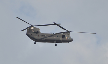
Wim Sonneveld was here and took a pictures of a Chinook from spot 6, so you can do the same!

Frequencies

121.900Ground
120.300/239.000 Tower
125.100Norcal Dep.
123.850/124.800/125.100 Norcal App
118.250ATIS
139.400/356.900ArNG Ops

Based Operators

B/1-126th AVN (HH) CA ArNGCH-47F
A(-)/3-140th AVN (SS) CA ArNGUH-72A
Allegiant AirlinesA319, A320

Preserved

variousStockton Field Museum
70-15987AH-1S, preserved at US Army apron, spot 3
89-00177CH-47D, preserved at US Army apron, spot 3

More Info

Airport DiagramAirport Diagram with runways and taxiways

Other Airfields

Barstow-Daggett  
Edwards AFB  
El Centro NAF  
Fresno Yosemite Intl
Hemet - Ryan Field  
Imperial Beach NOLF
Lemoore NAS - Reeves Field  
March JARB
Miramar MCAS  
Moffett Federal Airfield
North Island NAS  
Palmdale Regional - Air Force Plant 42
Point Mugu NAS  
Sacramento - Mather
San Francisco - Intl  
Santa Monica - Municipal
Stockton Metropolitan
Travis AFB  
Van Nuys  

Send Updates

Do you have updates? Or is something not listed correctly? Please let us know! You can help us and other spotters with your information.
Invalid Input
Invalid Input

0/255

Invalid Input
Invalid Input

Subscribe to Scramble

As a member you get access to all our
premium content and benefits learn more