Travis AFB

Back to Country
ICAO Code KSUU/SUU
Last Validated 01-2023
City Fairfield
Position 38°15'52"N 121°55'27"W
Runway(s) 03L/21R, 03R/21R
Elevation 63 ft

General

Travis Air Force Base is a United States Air Force base under the operational control of the Air Mobility Command (AMC), located three miles (5 km) east of the central business district of the city of Fairfield, in Solano County, California, United States. Situated at the southwestern edge of the Sacramento Valley and known as the "Gateway to the Pacific," Travis Air Force Base handles more cargo and passenger traffic through its airport than any other military air terminal in the United States. The base's host unit, the 60th Air Mobility Wing, is the largest wing in the Air Force's Air Mobility Command, with a versatile fleet of C-5M Galaxies, KC-10A Extenders, and C-17A Globemaster III aircraft.The base's former Strategic Air Command Alert Facility is now a U.S. Navy complex that typically supports two transient Navy E-6B Mercury TACAMO aircraft assigned to Fleet Air Reconnaissance Squadron THREE (VQ-3) Detachment and normally home-based at Tinker AFB, Oklahoma. ( Source: Wikipedia)

Layout

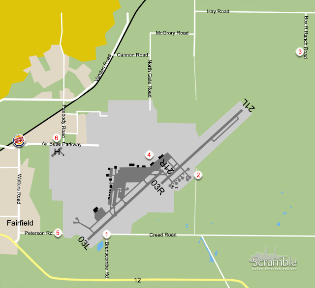
Fairfield/Travis AFB has two large runways in southeast/northwest direction. North of the runways are the huge ramps. In the northwest corner there is a small airfield used for helicopters nowadays who are visiting the next door hospital.

Getting There

Coming from San Francisco and Oakland, or from Sacramento, you take Interstate 80 towards Fairfield, leaving via Route 12 towards the base.

Around the Airport

1Runway 03L/21R and Ramp

Driving on Highway 12, take a left at Branscombe Road and drive towards the end. Park your car on the south side of the road and position yourself. Here you have a good view onto runway 03L/21R operations and you can take shots with around 200mm onto the runway while using a small step or the back of your pickup truck. You also have a good view onto the ramp and, depending on heatwaves you can read the numbers of the parked aircraft. For more registrations, just move along Creek Road to have a good view onto the parked aircraft with a 50x viewer.

2Runway 03R/21L and Ramp

Driving from spot 1 on Creek Road, you will notice a road to the left towards the south ramp area. Here a stored C-5A 70-0451 is parked for future use in the museum. This road could be gated and locked. In that case walk the road towards the end to have a look onto the eastern ramp. This is best in the morning due to the angle.

3Landing Runway 21L

When leaving Interstate 80 and driving on Highway 12, take a left at Walters Road, take a right at Air Base Parkway, take a left at Peabody Road onto Vanden Road. Follow this road towards the east and take a right at Cannon Road. Take the next right, next left, next right and next right to end up at Hay Road. Follow this road to take a right at Box R Ranch Road. Follow this to the end, park your car sensibly to have a view onto the landing traffic. Best in the afternoons.

4Travis AFB Aviation Museum

On the base you will find the Travis AFB Aviation Museum. This is a large museum with many aircraft. As this museum is on the base, you will have to follow Air Base Parkway towards the gate for entrance. Procedures for entrance are noted on the website, see More Info, but be notified that access for non- USA visitors could take 3-5 weeks.

5Landing Runway 03L

When leaving Highway 12 onto Walters road, take a next right onto Petersen Road towards the Commercial Truck gate and the Irving H. Lambrecht Sports Complex. Park your car at the sports complex and position yourself for landing traffic in the afternoons. For morning shots, alternative to spot 1, you can drive up the dirt road opposite the sports center.

6View onto helicopter field

While driving on Air Base Road, do have a look to the south to have a view onto the helicopter landing spot here. Sometimes there is helicopter parked here.

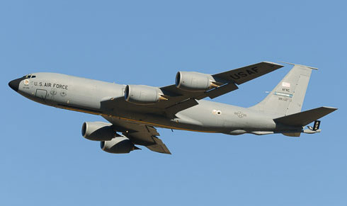
A visiting KC-135 is taking off from runway 21L and photographed from spot 1. (Erik Sleutelberg)

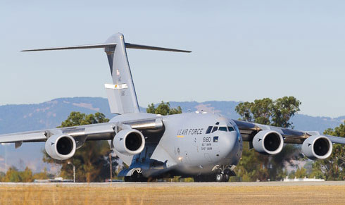
A C-17 of the 60th Air Mobility Wing seen from spot 1, as it enters runway 03L. (Erik Sleutelberg)

Frequencies

335.800 / 127.550Clearance Delivery
289.400 / 121.800Ground
239.050 / 254.400 / 120.750Tower
281.450 / 322.325 / 119.900Departure North
306.900 / 126.600Departure South
281.450 / 322.325 / 119.900Approach North
398.200 / 126.600 / 128.400Approach South
292.125 / 135.550ATIS
349.400 / 141.900Command Post

Based Operators

60th AMW
6th ARSKC-10A (black/white)
9th ARSKC-10A (black/white)
21st AS C-17A (black/white)
22nd ASC-5M/C-5M(SCM) (black/white)

Preserved

variousTravis AFB Aviation Museum
63-7567/FJ-567F-4C, near Hospital gate
62-4452CT-39A, near Hospital gate
51-17651C-118A, middle of field.
63-8088C-141A, close to flightline

More Info

Travis AFB Aviation Museumsite of museum
Travis AFB diagramdiagram of Travis AFB with all frequencies and taxiway naming.

Other Airfields

Barstow-Daggett  
Edwards AFB  
El Centro NAF  
Fresno Yosemite Intl
Hemet - Ryan Field  
Imperial Beach NOLF
Lemoore NAS - Reeves Field  
March JARB
Miramar MCAS  
Moffett Federal Airfield
North Island NAS  
Palmdale Regional - Air Force Plant 42
Point Mugu NAS  
Sacramento - Mather
San Francisco - Intl  
Santa Monica - Municipal
Stockton Metropolitan
Travis AFB  
Van Nuys  

Send Updates

Do you have updates? Or is something not listed correctly? Please let us know! You can help us and other spotters with your information.
Invalid Input
Invalid Input

0/255

Invalid Input
Invalid Input

Subscribe to Scramble

As a member you get access to all our
premium content and benefits learn more