Corpus Christi IAP

Back to Country
ICAO Code KCRP/CRP
Last Validated 11-2024
City Corpus Christi
Position 27°46'20"N 097°30'09"W
Runway(s) Rw 13/31, 18/36
Elevation 46 ft

General

in 1956 Corpus Christi voters approved a $3.2 million dollar bond to build a new airport to replace the existing Cliff Maus airport. Construction began in 1958 and was opened on August 6, 1960. In 1998 Corpus Christi City Council approved a $22 million dollar plan to replace the nearly 40-year-old terminal. The 165,000 square-foot Hayden W. Head Terminal opened on November 3, 2002. The terminal was named after Hayden Wilson Head, prominent South Texas attorney, civil leader, and aviator, who served as Chairman of the Corpus Christi Airport Advisory Board from 1956 until his death in 1987.In 2016 the U.S. Coast Guard built a state-of-the-art, mission critical facility designed for the U.S. Coast Guard Command. The 160,503 square-foot facility consists of an office building and aircraft hangar and includes command facilities, data centers, maintenance shops, and berthing for ready crews.

Layout

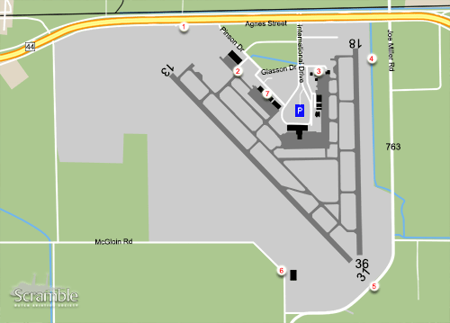
With the terminal in the middle, there are two runways east and west of the terminal. There is a large apron to the east, with the Sterling Air FBO, Del Mar College and CAP Corpus Christi, and two large aprons to the west, with Atlantic Aviation FBO and the USCG.

Getting There

Coming from the north, you drive on Highway 37 towards Corpus Christi. Take Exit 4A NAS-CCD Corpus Christi onto the 358 to the South , then take the exit towards Texas 44 Robstown/Alice. On this highway, after passing the airport, take the first exit to the right towards Route 2292 Clarkwood Road.At the traffic lights, take a left under the highway then lefty again onto Agnes Street. This is a one way trunk route.

Around the Airport

1Landing RWY 13

At Agnes Street park your car at the Crash Gate or at any convenient position to have a view onto landing traffic on the main runway 13. At the crash gate you also have a distanced view onto the taxiway onto rwy 13.

2View onto USCG platform

From spot 1, follow Agnes street and take the first to the right onto Pinson Drive. You will see the large USCG building with its preserved HU-25. Next to it is a small road leading to a crash gate. You can drive into it and make a 180 degrees turn at the end. From a ladder or your pick up truck you have a good close by view onto the USCG apron and a view into the hangar. Loitering here is not advised.

3View onto the East Apron

From spot 2, continue onto the road, now called Glasson Drive, cross the International Drive and drive towards the Del Mar College building. Next to it is a small hill which will gives you a good view onto the apron and the T-34 used by the college. All planes parked at this ramp can be photographed from there are ample spots between the hangars along Hangar Lane.

4Along RWY 18/36

From spot 3, drive back towards International Drive and take the right towards Agnes Street. Here take a right, follow Agnes Street and take the first right onto Joe Miller Road. From here you have a good view onto the runway and apron. For photography with the right car, from Agnes Street, take the right onto the grass to follow the fence to your preferred position. You can vacate at the end again onto Joe Miller Road.

From spot 4, follow Joe Miller Road to cross the extended of runway 36 and 35. Position yourself here depending on landing runway and sun position. If needed park your car at the small road to the west.

5Near the FAA building

From spot 5 drive along the fence onto a small road then take a right onto McGoin Road. When the FAA building and tower are at your right and the road makes a curve, there is a spot at the corner with an afternoon view onto runway 13/31. A ladder or pick up truck is needed to overlook the fence.

6View onto West Apron

From spot 1, continue on Glasson Drive and take the first right onto Pinson Drive. You pass the hangars including the Atlantic Aviation FBO. Next to the hangars are spots to overlook the apron. Aircraft from Corpus Christi NAS are known to use this FBO.

Piet Luijken

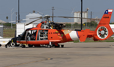
After leaving the highway, stop at the crash gate for spot 1 and you have a view onto the taxiway for some afternoon shots like this USCG HC-144B

Piet Luijken

Driving up the small road towards the crash gate at spot 2 and standing on your truck or ladder you have a good close view onto the USCG platform.

Frequencies

118.550Clearance Delivery
121.900Ground
119.400Tower
120.900/124.800/125.400Approach/Departure
126.800ATIS

Based Operators

USCG Corpus ChristiMH-65E, HC-144B

Preserved

2105HU-25D, preserved at spot 2
160274/771T-34C, i/a with the Del Mar college at spot 3

More Info

Corpus Christi IAP websiteWebsite about Corpus Christi IAP.
FAA Airport DiagramFAA Airport Diagram of Corpus Christi IAP.

Other Airfields

Arlington MAP
Austin-Bergstrom IAP
Corpus Christi IAP
Corpus Christi NAS (Truax Field)  
Corpus Christi-Cabaniss Field NOLF
Corpus Christi-Waldron Field NOLF
Dyess AFB  
Fort Worth - Alliance  
Fort Worth - Sycamore Strip  
Fort Worth Meacham IAP
Fort Worth NAS - JRB Carswell Field
Houston-Ellington Field  
Kingsville NAS  
Lackland AFB & Kelly Field  
Martindale AHP
Orange Grove NOLF
Randolph AFB
Sheppard AFB - Wichita Falls MAP
TSTC Waco

Send Updates

Do you have updates? Or is something not listed correctly? Please let us know! You can help us and other spotters with your information.
Invalid Input
Invalid Input

0/255

Invalid Input
Invalid Input

Subscribe to Scramble

As a member you get access to all our
premium content and benefits learn more