Randolph AFB

Back to Country
ICAO Code KRND/RND
Last Validated 04-2023
City San Antonio
Position 29°31'47"N 098°16'44"W
Runway(s) 15L/33R, 15R/33L
Elevation 762 ft

General

Randolph Air Force Base lies some 15 miles east-northeast of downtown San Antonio, Texas. It was opened in 1931 and has been a flying training facility for the USAAC, the USAAF, and the USAF ever since. Nowadays, the resident 12 FTW provides instructor pilot training, refresher/recurrency training and navigator training (including naval and NATO/allied flight officers) in the T-6A, T-38 and T-1A Jayhawk.

Layout

The air base has two runways, both north-south orientated. In the middle, on the north side, are the aprons. Most aircraft are parked under sun sheds.

Getting There

Randolph AFB is located south of Route 78/Gordon A Blake Highway/Route 218 and east of Route 1604. From San Antonio go to Seguin via Interstate 10. Take exit 587 and take a left at the crossroads onto Route 1604. In a while, you will see the air base at your right.

Around the Airport

1Afternoon view onto western apron

A view onto the western aprons can be had from spot 1, best in the afternoon. Park your car along Route 1604, for instance at the gas station Valero and position yourself to view the apron.

2Landing spot 32L

Driving on Route 1604, take a right onto Lower Seguin Road, that is across the Exxon gas station. On this road you will pass the extended runway of 32L. Park your car on the south side of the road and position yourself also on the south side of the road, for instance along the dirt road.

3Landing spot 32R

From spot 2, continue on Lower Seguin Road untill you pass the extended runway 32R. Park your car on the south side of the road and position yourself also on the south side of the road, for instance along the small road.

4Morning view onto eastern apron

From spot 3, continue on Lower Seguin Road, untill you arrive at the crossing with Route 1518. Take a left here and continue on Route 1518 and take a left at Shaefer Road. Just before the bend, you arrive at the private gate of Bella Oaks Farm. From there, you have a reasonably good view onto the southern and eastern aprons. Should you be able to contact the farm owners and they allow it, you may walk to the base fence for a better view. Be advised that parking is not allowed at the end of Shaefer Road and police do enforce this.

5Morning view onto eastern apron

Driving on Route 1518, you will pass a V-shaped sewage system. after some housing and Industrial area, there is a unoccupied piece of land. take the small road to the left, park your car and walk up to the fence for a good morning look.

6landing spot 14R

Driving on Route 78/Gordon A Blake Highway/Route 218, across the entrance to Randolph AFB, take a left onto Pat Brooker Road. Take a direct right onto E Aviation Boulevard and continue untill you see the runway at your right. Park your car in the waste land and position yourself with regards to the poles. For afternoon shots there is a small road to your right towards some bushes away from the poles. For morning shots, you have to ga near the small creek.

7Landing spot 14R

Referring to the previous spot, when on Pat Brooker Road across the entrance to Randolph AFB, take a direct left onto W Aviation Boulevard and continue past the houses. Park your car here and position yourself with regards to the sun.

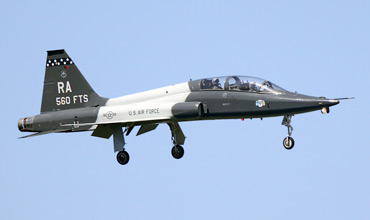
Resident 560th FTS Talon caught on final for 15L, shot from spot 6 by Ramon Berk.

Frequencies

338.350CLNC DEL
119.750/275.800Ground
128.250/258.300 Tower
127.100/128.050 San Antonio DEP
251.125/318.100 San Antonio DEP
124.450/127.100/128.050 San Antonio ARR
251.125/318.100San Antonio ARR
271.800ATIS

Based Operators

Randolph Composite Sq (Civil Air Patrol)C-182T
99th FTST-1A (bk/ye)
435th FTST-38C (light blue)
559th FTST-6A (bk/wh checkerboard)
560th FTST-38C (bl/wh stars)
PTN det.24T-6B (E/G-xxx)
415 FLTST-38A/C

Preserved

49-1695T-28A, preserved on base, as '17882'
53-3489T-29C, preserved on base
53-6147/TR-147 T-33A, preserved on base
54-2730/RAT-37A, preserved on base, as '62-730'
61-0838/RAT-38A, preserved on base
65-5226/N5226FT-41A,preserved on base
73-1153/RACT-43A, preserved on base, as '562 FTS'
44-81910/TA-560AT-6F, preserved on base, as '84560'

Other Airfields

Arlington MAP
Austin-Bergstrom IAP
Corpus Christi IAP
Corpus Christi NAS (Truax Field)  
Corpus Christi-Cabaniss Field NOLF
Corpus Christi-Waldron Field NOLF
Dyess AFB  
Fort Worth - Alliance  
Fort Worth - Sycamore Strip  
Fort Worth Meacham IAP
Fort Worth NAS - JRB Carswell Field
Houston-Ellington Field  
Kingsville NAS  
Lackland AFB & Kelly Field  
Martindale AHP
Orange Grove NOLF
Randolph AFB
Sheppard AFB - Wichita Falls MAP
TSTC Waco

Send Updates

Do you have updates? Or is something not listed correctly? Please let us know! You can help us and other spotters with your information.
Invalid Input
Invalid Input

0/255

Invalid Input
Invalid Input

Subscribe to Scramble

As a member you get access to all our
premium content and benefits learn more