Lackland AFB & Kelly Field

Back to Country
ICAO Code KSKF/SKF
Last Validated 02-2024
City San Antonio
Position 29°23'03"N 098°34'52"W
Runway(s) 16/34
Elevation 690 ft

General

-- This guide is being reworked --

Lackland Air Force Base, together with the Kelly Field airport under its control, is part of Joint Base San Antonio (JBSA) that also comprises Randolph AFB, Martindale AAF and Fort Sam Houston (USAr). The airfield part is on Kelly Field with Lackland AFB occupying a large piece of land west of that. The base is under the jurisdiction of Air Education and Training Command (AETC) and Kelly Field supports flight operations of the AFRC 433rd Airlift Wing's C-5s and the TX ANG 149th Fighter Wing's F-16s.

The east side of the former Kelly AFB used to house the San Antonio Air Logistics Center, normally packed with military heavy transport and tanker aircraft. Since 2007, this facility has officially been known as Port San Antonio and nowadays is used for both military and civilian aircraft. As Boeing is the main aerospace company operating here, part of the beforementioned aircraft can still usually be seen in the same area, along with jet airliners.

Layout

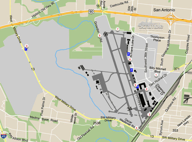
The airport has one north-south runway. West of that is where the Air Force units are have their home, the Fighting Falcons under sunsheds on the westernmost part and the Galaxies obviously on the very large apron. Most of the oldest aprons (not depicted on our map) have been relegated to vehicle movements decades ago and a number of runways/taxiways closed. The east side of the runway is lined with aprons, and hangars of which by far the largest are those at the former Logistics Center on the southernmost part of the field. Both military and civilian planes can pop up anywhere here, although the military ones will be mostly in the south.

Getting There

The airfield lies amidst the suburbs of southwest San Antonio, with US Highway 90 running along its northern perimeter. General Hudnell Drive, also called Spur 371, can be seen as the main entrance road (from the east) and signs towards Port San Antonio will lead towards it from the US 90 out of central San Antonio. To reach any of the spots directly, leave the respective highway for the roads mentioned on our map, that will appear on the exit signs.

Around the Airport

1Preserved Aircraft

In the triangle formed by General Hudnell Drive, Billy Mitchell Boulevard and Southwest 36th Street, four preserved aircraft are on display: a B-58 and F-111 at 3133 General Hudnell Drive, an F-106 behind the Northrop Grumman/Lockheed Martin building and an F-15 opposite the Texas Learning Center on Billy Mitchell Boulevard.

2Boeing gate

A hit and run location located at the end of General Hudnell Drive, to possibly poll some IDs of aircraft on the northern part of the Boeing aprons.

3Port San Antonio south view

Running along the southeastern perimeter is Bernan Road, that offers views from that side onto the Boeing facilities. It is not good for photos due to obstructions but reading off a large part of the aircraft present should be possible while moving along the fence here. Should there be landing traffic on runway 34, this could also make for a suitable photo spot in the morning. To get here from the previous spots, take Clarence Tinker Drive (the extension of SW 36th St) southbound and at the end follow it to the right where it becomes Bernan Road, along the railway. There is a parking lot opposite the last buildings that you may be able to use.

4Oscar Westover Road

Continuing south from spot 3, you will get to the an underpass of West Military Drive. Just before it, a No Outlet road branches off to the right and crosses the runway centreline, towards a closed gate. This is Oscar Westover Road and it will offer a good afternoon view on aircraft using runway 34 but we do not know if staying there (and taking photos) will be accepted by authorities. However, from the junction, there is a very acceptable albeit distant view onto the Galaxy ramp, plus another angle to check out the Boeing facilities. You may also be able to spot the F-105 that has been parked on the westernmost closed taxiway for a long time.

5South Frank Luke Drive

Of a number of parking lots along Frank Luke Drive, that borders the very long north-south apron of Port San Antonio, the southernomst one extends the furthest towards the runway, enabling you to see otherwise obscured parts of the ramp. It is situated behind the Standard Aero building and designated for employees and visitors only. You get here from spot 1 by driving around said large building.

6North Frank Luke Drive

Frank Luke Drive is really one long spotting location for those who want to score the maximum number of airframes present. Some of the better views can be had north of Billy Mitchell Boulevard where a number of airliners may still be stored close to the fence. Further north on the apron is where the bizjets and smaller aircraft usually park, at the FBOs.

7North view and runway 16am

A final viewing point for airliners in storage or maintenance, plus a vantage point for movements with southern winds, requires a bit of a detour from the previous spots as the road it is on was separated from SW 36th Street in 2011. To get to this spot from Frank Luke Drive, proceed north and turn left onto 36th Street. Take first left after crossing underneath the highway, onto the US 90 Access Road. Then follow the signs for Acme Road, which also works when arriving directly from US 90 from either direction.

Turn towards the airfield onto South Acme Road at the junction below the overpass of Texas Highway 151, and then left onto Growdon Road along the fence. Closest to the Boeing hangar will be a good starting point to read off anything parked south of the spot. It seems OK to park your car on the verge here. Walking back to the bend in the road should put you at a fine location to watch and photograph flying activities on runway 16 in the morning.

8Runway 16 pm

Following the directions to spot 7 but turning right from Acme Road towards the Lackland AFB Commercial Vehicle Gate obviously brings you to the other side of the runway, also on Growdon Road. There is room to park along the road opposite the holding point of 16, a good point to enjoy and catch on sensor any flying activities in the afternoon. Further towards the gate are two small roads to the right, of which the second one used to provide a distant look at the F-16s. It is no use going there anymore though, as there is far too much vegetation blocking the view.

9Luke Gate and Parade Field

Southeast of the Lackland AFB Luke Gate Visitor Center lies the Lackland Parade Field with a great collection of military aircraft on very open display. The 30+ airframes vary from a T-34 to an SR-71, from an F-15 to a B-29 and more. Permission to visit Parade Field can be obtained, even for non-US citizens given enough time and providing certain information on request. See the More Info panel for a point of contact. Without a permit, the collection can still be seen at various distances from West Military Drive and the parking lot at the gate. Further north, on the same side of the road, three more aircraft are on display at the base - see Preserved panel.

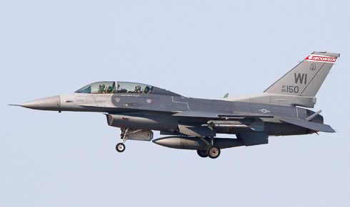
F-16D on TDY landing on runway 16, as seen from spot 7 by Robbert Snijders.

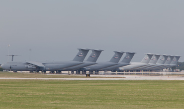
Many Galaxies can be seen, read and photographed from spot 4, as shown in this picture by Reinold Kalsbeek.

Frequencies

121.800 / 289.400Ground
124.300 / 322.350Tower
125.700 / 290.225Departure
118.050 / 353.500San Antonio APP
125.100 / 307.000San Antonio APP
127.100 / 269.100San Antonio APP
138.600 / 252.100AFRC Command Post
122.950 / 126.200 / 372.200Pilot to Dispatcher
120.450 / 273.500ATIS

Based Operators

182nd FS, 149th FWF-16C/D
86th & 356th AS, 433rd AWC-5M

Preserved

Lackland AFB houses a large number of preserved and instructional airframes. We try to list those that are, or may be, visible from outside the fence, apart from the Parade Field collection.
59-2437B-58A at spot 1
71-0878C-9A north of spot 9
43-48415EC-47 as as '43-201' north of W Military Dr opposite Whitewood St
54-0593C-123K north of spot 9
57-2589C-135E west of spot 9 (outside map)
02-9111E-8C stored northwest of spot 4
76-0108F-15A at spot 1
52-8889F-84F south of spot 9 as '52-6718'
47-0605F-86A south of spot 9 as '51-2959'
57-1319F-104B as Chapman Training Annex gate guard, west end of Medina Base Rd (outside map)
54-0105JF-105B south of spot 9
62-4279F-105 stored northwest of spot 4
57-2533F-106B at spot 1
68-0275F-111G at spot 1
68-6865O-2A as '21440', with EC-47 above
51-5172VT-29B north of spot 9
59-1605T-38A west of F-104 above

More Info

JBSA Public AffairsJoint Base San Antonio official website

Send Updates

Do you have updates? Or is something not listed correctly? Please let us know! You can help us and other spotters with your information.
Invalid Input
Invalid Input

0/255

Invalid Input
Invalid Input

Subscribe to Scramble

As a member you get access to all our
premium content and benefits learn more