ICAO Code LGLR/LRA
Last Validated
City Larisa
Position 39°39'01"N 022°27'56"E
Runway(s) 08/26
Elevation 241 ft

General

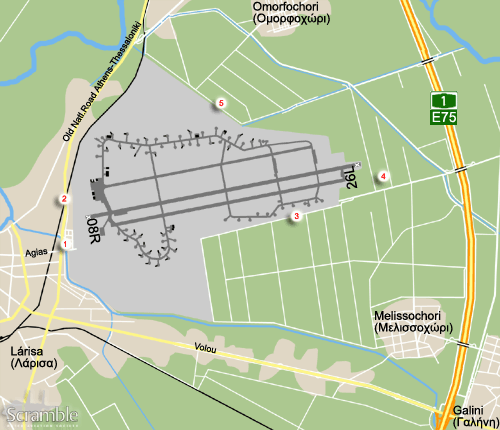
Larisa (Λάρισα) air base is situated east of town west of highway 1/E75. This is a fairly new road and on many maps the airfield is falsely marked to the right of what seems to be the highway but is in fact the old one that runs to the west of the air base!

Layout

The base has three parallel stretches of tarmac, but only the southern one is actually in use as runway. The southwest corner has a shelter area were 346 Mira resides. The southeast has a dispersal area used for storage of aircraft but also drop tanks and the like. The north side dispersal area is used by the RF-4E from 348 Mira and the new 337 Mira F-16C/D block 52 are probably also operating from this side.

Getting There

This is rather straightforward. Take the Larisa exit off highway 1/E75. For spots 1 and 2 proceed on Volou to the city. For the other spots make a right for Melissochori (Μελισσοχώρι).

Around the Airport

1West side approach runway 08R

Upon entering the outskirts of Larisa on Volou road, make a right onto the old Athens-Thessaloniki national road. Stay on this for about 1 km, then you will have reached the traffic lights at the base entrance road. On the other side of that cross roads you have to make a right while the road is starting to slope up for the railway crossing. This road leads down into a small residential area and the aircraft pass straight overhead here. It is not ideal, you stand out and the road is also used by smart Greek military trying to avoid the traffic lights. You can almost read the aircraft without bins though.

2West side overview

Continuing onto the bridge over the railroad will render a view of the southwest shelter area, the main ramp and the heritage park with some preserved aircraft. This is a busy road however, so really hit-and-run and be lucky or leave your car and walk up the bridge which has no pavement.

3Southeast side storage

The southeast side contains some dispersals filled with old aircraft probably serving as decoys. The get here there are several routes. For the easiest one, take the Melissochori exit of the road from the highway to Larisa. This road will take you northeast into the village. There is basically one decent road going straight north out of the village, this is the one that runs along the west side of the town square. After a little less than 2 km the road meets a better asphalt road running straight into the base, make a left onto this one. You are now approaching the far southeast corner of the base which has a gate. About 200 metres before this gate, there is a farm track on the left side, go in there, it bends right immediately after and you are now driving parallel to the paved road which is on the inside of the fence. The stored aircraft will appear on your right within 1 km.

The shortest route, but one that will get your car dirtier, is to keep left at the Y-junction upon entering Melissochori village. Take the first left and then again the first left. You are now on the southern track of the 'grid' of farmland roads lining the southeast side of the base. Pick a decent one to your right and work your way to the base perimeter. You can also make a left from the road that goes north out of Melissochori as described in the previous paragraph. This road starts at a cross road about 500 metres north of the village. It will bring you to the central track and you can make a right to reach the fence from that as well.

Lastly there are two routes on either side of the highway. For the first one, exit the highway in the direction of Larisa but make a right immediately after. This road bends right, then left and you are driving right next to the highway on the west side. Proceed on this road until you have reached a canal and are forced to make a left turn. The road is a gravel track by now. Were it meets the paved road make a left; this is the road to the aforementioned gate again. The second option is the longest but is paved all the way to the gate. Take the Larisa exit but go east towards Platikambos (Πλτύκαμπος) but take the first road left, northbound and stay on this until the T-junction which is about 4 km. Make a left, cross the highway and when the road bends right on the east side of the canal, go straight keeping left and crossing the canal. This is the same road for the gate again.

4East side approach runway 26L

From the asphalt road to the secondary southeast gate, refer descriptions under spot 3, take one of the farmland tracks on the north side. Find a tree of park your car out of sight from the gate and nearby farms. Most of the time people will be working the land, but it is a lot quieter than the 08 approach!

5North side views

The northwest side taxi track with stored aircraft, the aircraft parked in the northern dispersals, and the north side dump, can be viewed from farmland tracks on the north side of the base. You will need to get to the asphalt road running east of the canal. From the gate described at spot 3, head back for this canal, cross the bridge over it and make a left. After 2 km, you can cross the canal, make a left there. The track bends left immediately and then sharply to right. Follow the track towards the base, but cross the canal to the north side again after about 800 metres and proceed on the northern bank. You can go reasonably far although the track becomes worse further down and trees start blocking your view anyway.

Alternatively, you can approach from further away, which is less conspicuous and a bit higher as well. For this you will not have to pass the canal but make a left just after the small bridge as described under spot 5. Keep the canal on your left and drive on for a km or so. You can cross the canal a bit further down this road and head south towards the base again. This road will meet the farmland track described in the previous paragraph. This alternative is also useable with bad weather conditions because the roads are slightly better due to their gravel surface.

Can you go around the base? Yes you can, which also means you can reach spot 5 from the northwest. After crossing the railroad, refer spot 2, proceed on the main road. Some 2.5 km after the bridge over the rail road tracks there is a main road to the northeast towards Omorfochori. Make a right into this road, it crosses the railroad again and shortly after you will see a brick factory. Make a right and go left immediately, go clockwise around this factory, thus making a sharp right at the Y-junction. This road will also bring you to the farmland track described in first instance under spot 5. It is also close to the spot were the track described in the previous paragraph meets this farmland track and the airfield perimeter fence.

Frequencies

120.550Tower / approach
122.100Tower / approach
257.800Tower / approach
362.300Approach

Based Operators

110 PM
337 MF-16C/D-52
346 MF-16C/D-30
348 MTARF-4E

Preserved

68-0506F-4E, gate, special c/s
38430F-5A, gate
37588RF-84F, gate
37683RF-84F, stored in hangar on base
35494/TR-494T-33A, north side shelter area
Memorial park on base
69209F-5A
28728RF-84F
37050/050F-84F
19752/FS-752BF-84G
19409CL-13 Sabre 2
61232F102A
6692/FG-6692F-104G
29913/TR-913T-33A
Storage - southeast side
11294F-84F, front half only, 1st dispersal
27470F-84F, 1st dispersal as '57470'
01619, 01620RF-5A, 2nd dispersal, camo c/s
10569, 13376F-5A, 2nd dispersal
50476, 97105F-5A, 2nd dispersal, camo c/s
89054F-5A, 2nd dispersal, blue c/s
89066F-5A, 2nd dispersal
97164RF-5A, 2nd dispersal
01399, 10566F-5A, 3rd dispersal
01617RF-5A, 3rd dispersal
89064F-5A, 3rd dispersal, blue c/s
97165RF-5A, 3rd dispersal, camo c/s
12601/FG-601F-104G, 4th dispersal
58602/TR-602T-33A, 4th dispersal
58639/TR-639T-33A, 4th dispersal
Storage - north side
35+07, 35+13RF-4E, NE taxiway
35+46, 35+84RF-4E, NE taxiway
68-0408, 68-0517F-4E, NE taxiway
67-0377, 68-0363F-4E, disperals in shelter area
68-0381, 68-0426F-4E, disperals in shelter area
68-0444, 68-0481F-4E, disperals in shelter area
7482, 7535RF-4E, disperals in shelter area
28736RF-84F, disperals in shelter area
?F-84F, dumped far north corner (marked .17.. on one side and ..788 on the other)
29561/TR-561T-33A, dumped far north corner
36082/TR-082T-33A, dumped far north corner
?T-33A, dumped far north corner (possibly 16867)
In town
89083F-5A, Tactical AF HQ, on Agias road opposite base entrance
6668/FG-668F-104G, Tactical AF HQ, on Agias road opposite base entrance
(51-3930)UH-19B, Soukas Robotics, Km12 on Old Natl. road.

Other Airfields

Agrinion  
Alexandria
Almiros - Nea Anchialos
Andravída  
Araxos  
Elefsis  
Gouviá SPB - CLOSED
Iraklion - Nikos Kazantzakis  
Kalamáta  
Kerkira - Ioannis Kapodistrias  
Kotroni  
Larisa
Megara - Pahi  
Preveza - Aktio  
Stefanovikio  
Tanagra  
Thessaloniki - Sedes
Tripolis

Send Updates

Do you have updates? Or is something not listed correctly? Please let us know! You can help us and other spotters with your information.
Invalid Input
Invalid Input

0/255

Invalid Input
Invalid Input

Subscribe to Scramble

As a member you get access to all our
premium content and benefits learn more