Apart from these spots there are more possibilities for those who look well or want a specific view, but generally these will suit all needs. For photography, the average lenses will do fine at the mentioned locations.
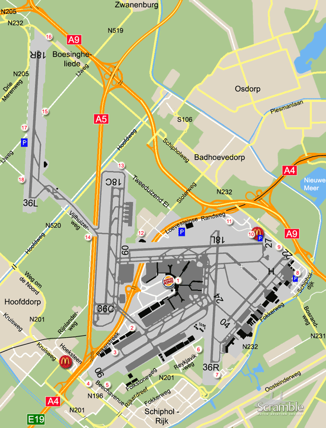
1Panorama Terrace
Once consisting of two terraces on top of terminals 1 and 2 that were connected, the part between the E and F pier was closed years ago. The remaining part overlooks the D and E aprons and runway 18L, plus parts of runways 24 and 27. Also, Schiphol East and runway 22 are visible in the distance. A large part of the traffic will at least taxi within view here when inbound or outbound, but certainly not all of it. Especially commuters and cargo planes may escape you when staying here. The fence is conveniently low, so good for photography. The preserved Fokker 100 is here, too. Entrance is free via Departures 1. The opening hours are: 09.00-17.00LT in Winter (starting last Sunday in October) and 07.00-21.00LT in Summer (starting last Sunday in March). The rest of the terminal area offers limited possibilities to those who go looking for them.
2Taxiway Q
This spot, and the adjacent part of the Pelikaanweg, have been absorbed into the construction area for the new southern taxiway, parallelling Q. If a similar spot emerges along the new taxiway, we will report so here.
3R-apron
Continuing on the Rijkerstreek past the Uiverweg (see spot 2), take the next left: the Toekanweg. Next to a crash gate, the cargo stands on this apron can be seen, and sometimes aircraft can be photographed provided you bring steps. There are some possibilities for pictures of 06/24 traffic, with acceptable light conditions from halfway in the afternoon. Mind that parking is not allowed anymore anywhere in this area.
4Approach lights 06
Leave spot 3 and carry on to the south, parallel to the motorway. At the end turn left onto the byway of the N196. This goes right underneath final 06, the so-called 'Kaagbaan'. Parking is very limited here so often if you want to stay at spot 4 the advise is to walk there from a distant parking, take a bus or ride a bike. The view is good and the excitement of the jet noise can be high. Head-on shots of 24 departures possible.
5South side 06
Schiphol's brilliant viewing area, including the best official 'Spottersplaats' and magnificent close views on traffic from/to the S-apron in later years, was declared closed on 27 January 2008 (inaccessible by early May). Expanding cargo facilities put an end to this long-standing tradition of aircraft spotting in Amsterdam, at vantage points of world fame along runway 06/24. The closest alternatives have been found near the junction of the Aalsmeerderweg (southern extension of Folkestoneweg) and Beechavenue, the current spot 5. This area can be reached from spot 3 and from Schiphol-Rijk, but not directly from the N201.
Runway 06/24 or 'Kaagbaan' has more traffic than any other, and the light here is OK until halfway the afternoon. Reading numbers of 06/24 traffic should be no problem but other (taxiing) traffic is generally too far away. Due to ongoing development of business areas, the parking spots that used to be available abeam the threshold of 06 had gone by early 2016. If still being able to park a car in this area please do it legally, meaning certainly not in the bend of the road or otherwise obstructing the path of frequent lorry traffic.
6West side 18L/36R
The best location here is the open field near the freight handling area, along the Reykjavikweg. Unfortunately, this too has been made a no-parking zone. For afternoon landing shots on 36R, this is still the best spot. It is rather far from the beginning of 18L so many departing aircraft are already quite high when passing it. The view is great otherwise, without obstructions for the time being. Be advised: although this is an area accessible to the public, security officials have been sending away airplane enthusiasts.
7Final 36R am
The location for landings on the 'Aalsmeerbaan' and also the planes that eventually land on 04 from this approach. Coming from spot 5, take the N201 towards the Waterwolftunnel but leave this road just before the tunnel itself. Via the roundabout pick up the Fokkerweg again and turn left at the traffic lights (opposite the petrol station). The spot offers a very good angle on arriving traffic and even heavies departing 18L can be photographed here, obviously with good light in the morning. Lots of parking space available during weekends but very limited on working days.
Should there be no room, an alternative spot is on the dike along the Ringvaart canal, close to the approach lights. It can be reached via the abovementioned roundabout. In this case, leave that roundabout away from the runway (to the south-west), take the first left and left again on the dike. Where to stand is self-explanatory, but the view is more obstructed here, by houses. A bit north from spot 7, at the Anthony Fokker Business Park, a Friendship is preserved nicely above a pond. This is c/n 10449 in the colours worn by the first F27.
8Schiphol-Oost
Schiphol's general aviaton area, and the technical area where you can see aircraft parked on aprons lower than boats in the adjacent canal! This area is easy to find and accessible from the Fokkerweg (from the south), the Schipholdijk (from the motorway) and the perimeter road (Loevesteinse Randweg, from the central area). Coming from the latter, the first hangar one passes is the police hangar. Photography on the GA apron is possible with steps, fee-less short-term parking should be no problem.
The general aviation terminal and related security and privacy concerns have taken out the spots on both sides of the coast guard hangar, but other spots are largely untouched. Bombardier's activities have unfortunately ceased again, after an interesting six years since 2010. Be advised that here too, extensive construction work is taking place leading to changed road structures and temporary closure of parts of the area. Aircraft in the maintenance base - actually all of the area between spot 7 and 8 - usually cannot be photographed from outside the fence but some registrations can be read off.
9Final 27
The abovementioned perimeter road crosses the approach lights of 22 and 27 and has unrestricted access from the designated entries. Parking and even stopping is not allowed here, so to spend some time at spot 9 park at East and walk, or walk from a bus stop (bicycles not allowed here). Again, this is a spot where you can stand right underneath landing heavies, quite a thrill. Runway 27 ('Buitenveldertbaan') is often not in use though, and runway 22 is merely for bizjets and light props of which there will be not too many. However, you may be lucky...
10McDonald's
Once a wasteland, this is now the oldest official viewing area, combined with a fast food restaurant. Often not the best option though due to backlight and lack of traffic (runway 09/27 is the most noise-sensitive one). However, a large part of the central area and East (GAT and maintenance base) are visible from here. With this runway active expect landings on 27 or departures from 09; they are rarely the other way around.
11Beginning 18L
This spot is reachable without restrictions by bus, bicycle and on foot. Access by cars is restricted, but still possible. The bus stop to get off is called 'Elzenhof', see our link to Openbaar Vervoer under More Info on the right. The spot offers a rather close view on traffic departing from the beginning of 18L, and offers good options for photos in the morning.
12Schiphol-Noordwest
Access to this spot starts at the Loevesteinse Randweg, between parking P3 and the tunnel. The Fire and Medical Training Centre has two helicopters as training objects, see panel on the right. The Mil can just be seen on the west side of the facilities, the Sikorsky is on an elevated platform and in plain view. Spot 12 is also close enough to the 'Uniform' buffer stands to read off what is parked there.
13Final 18C
To get here, leave the airport grounds and turn left onto the N232 towards Badhoevedorp from spot 10. Turn left again onto the Sloterweg in Badhoevedorp (Dorint Novotel on the corner) and then right onto the Tweeduizend El. This is the through-road at that point and you will see a VOR (antenna array) near the end. Pick your spot next to the approach lights but stay with the car, as this is no official parking spot. Just around the corner, west of the threshold, a short dead-end road gives some legal parking space. Runway 18C ('Zwanenburgbaan') is often used for landings, simultaneously with 18R. When active, this is a fine viewing place.
14Vijfhuizerweg
In the old days, before the existence of motorway A5 and the 'fifth' runway, photography and viewing along (then) 19R used to be excellent. At present, the view is more distant and obstructed, but not all is lost. Departures from 36C (often) or 18C (occasionally) usually climb above the fence quickly enough to take pictures of them. Quite a long lens is needed for that though, which is unusual at Schiphol.
A new attraction in this area is Taxiway Victor, connecting 18R/36L with the rest of Schiphol. Aircraft taxiing here do not only cross over the A5 but also over a canal (the Hoofdvaart)! Especially if you bring steps, taking photos along this taxiway is well possible, even near the canal bridges. If you are mainly after numbers, this is probably the best spot with the two western runways in use. Parking is prohibited along the connecting taxiway, which is enforced by police. Use the cemetary parking facilities. The pull-outs south of the spot, along the Rijnlanderweg, have unfortunately been blocked, possibly because of littering.
15Polderbaan a.m.
This spot is at one of the dead ends of the cut-up IJweg. A small roundabout and the verge offer a great view on 18R/36L. Unfortunately, the municipality of Haarlemmermeer has decided not to accommodate those who want to admire the airplanes, but to restrict their driving to this runway to one single location: the official 'Spottersplaats' at spot 17. All roads leading to spots 15, 17 and 18, after leaving the main road, became no-parking zones and 60 km/h zones in May 2010. The parts near the spots are even no-stopping zones. Police do enforce this regime by fining motorists.
To reach this spot by road (on pedal cycle, for instance) from spot 14, turn right onto the Hoofdweg (Oostzijde), then left at the traffic lights and, after passing underneath the A5, left again at the traffic lights in Boesingheliede. When at the spot, do not block the airfield gates please, and stay clear of the farmland! Be aware that departures are always on 36L, landings always on 18R.
16Final 18R
If you park along the byroad of the N232 in Boesingheliede and walk a little towards the approach lights, traffic on final for 18R can be photographed nicely. Especially in the morning this is a great spot, and gaining popularity. An alternative, for evening light photography, is to find a spot off the road that leads north from the roundabout near the approach lights (Spaarnwouderweg). Do not park in front of the crash gate on the centreline. It is amazing how far away from (the rest of) Schiphol you are here... 7-8 kilometres!
17Polderbaan p.m. (halfway)
One of two spots not far from each other, but giving different views. From spot 16, take a kind of left at the roundabout and left again at the traffic lights onto the Driemerenweg (N205). At the next lights turn left again and another final left at the junction with the IJweg (unusual situation with a bump). There is a roundabout similar to the one on the opposite side, with a no-parking and no-stopping situation as described under spot 15. Extra here however, is the official 'Spottersplaats' with parking lot, which opened early 2008. This is the only place along the runway where private vehicles will be allowed. The view on the Polderbaan is nearly unobstructed and photography is good for both directions of runway use. With landing traffic, the shots get more interesting by moving north along the cycling track (so riding here by bike is not a bad idea).
18Polderbaan p.m. (south)
The last spot in this long list and one that, when it became available, quickly gained enough fame to attract many enthusiasts for a day at the newest runway. Initially, it was possible to walk along the ditch, further towards the threshold, for marvelous head-on views of aircraft lining up on 36L. Unfortunately, this option too has been terminated, by a gate some 50 m from the roundabout. What remains is still a good spot to enjoy 36L departures, once you get here. Access is via the last junction described at spot 17, again to one of those small roundabouts and a crash gate. As described under spot 15, this area is also a no-go for aircraft viewers' cars since late 2010.


