Den Helder/De Kooy

Back to Country
ICAO Code EHKD/DHR
Last Validated 11-2024
City Den Helder
Position 52°55'24"N 004°46'50"E
Runway(s) 03/21
Elevation 3 ft

General

Since the closure of Valkenburg NAS, this is the remaining naval aviation base in Holland. Because the harbour of Den Helder is the main base for Dutch navy ships, the NH90 helicopters are based here. The airfield attracts visiting helicopters from other countries, both civil and military, and the occasional transport aircraft. Part of the field is civil and houses several helicopter companies and some general aviation. Den Helder is the main base for off-shore flying from the Netherlands and these movements usually make up the major part of daily traffic.

Layout

The terrain is flat and open with a lot of canals and ditches. With some moving around on several sides of the airport anything parked outside or flying should come into view.

Getting There

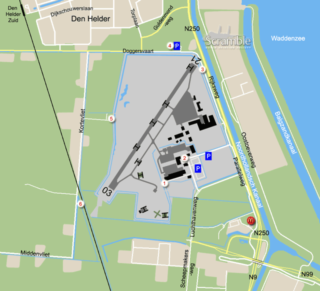
By car, use any of the three major roads coming together just southeast of the field to reach the area. Do not take the main road N250 towards Den Helder, but take the feeder road which starts at the McDonalds. Drive on this road called Doggersvaart to drive along the airport. There is an exit towards the civil terminal and another one towards the military area. Public transport gives two options. Den Helder Zuid train station is about a 25 minute walk from the field, and the Interliner bus from Den Helder's main railway station stops at the base.

Around the Airport

1Hangar row

At the Doggersvaart, take the first left onto Luchthavenweg. At the next crossing take a right and then left again. Park your car at the end. There is a practice helicopter landing and hover area east of the beginning of runway 03. From here you have a nice view on that area. Furthermore, when using runway 21, the departing traffic can be seen here. You can walk along the perimeter to a better spot.

2Civil terminal area

From the Doggersvaart, take the second left towards the civil terminal. Most of the civil aircraft and helicopters can be seen between the buildings. Photography is forbidden as signposted (on behalf of EASP Air) but you may still get away with a hit & run. Numbers can be scored without problems. You can also have a view onto the most westerly part of the military apron from the parking spots near the buildings.

3Final approach 21

Follow the Doggersvaart to this spot. Park your car at near the crash gate. You can stay at the gated area. At this spot, one can stand at either side of the centreline for landing or take-off shots (depending on the wind) and to read off the helicopters on the military apron. Due to the fences you will need a small step to photograph over the fence onto the heli spots, especially with easterly winds. Most of the time, with easterly winds, smaller helicopters will use the heli spot near this spot. Bigger ones will use the mid runway heli spot but will depart on runway heading and will not be too high. With westerly winds, all traffic will cross this spot while the smaller helicopters, like the Lynx, will use the taxiway close by to fly towards the apron with a nice turn. If you walk a bit to the south, towards the military gate, you will have a view of some parts of the military apron.

4Northern platform view

From the Doggersvaart, a bit west of the runway centreline, one has a good view of the military apron and the helos can be spotted from here, despite looking into the sun. Those on the civil part are further away but may be read off too. It is best to use the parking spot related to the cycling training grounds.

5West side

This side of the runway gives a clear view over the base. This is also an alternative to watch the practice areas along the runway and the beginning of 04 during the afternoon. While driving around the airport onto the Kortevliet, take the road towards the radar station.

6Final approach 03

This is one of the few options remaining to catch traffic about to land from the south, as the former spots have become inaccesible. Getting here is very easy, it is south of spot 5 and just across the railroad. Parking is possible providing your vehicle is not in the way of farm traffic.

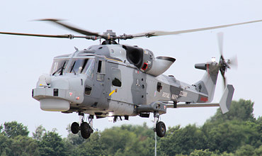
British Wildcat arriving at De Kooy for a fuel stop, enroute to Nordholz. (Edwin Daalder)

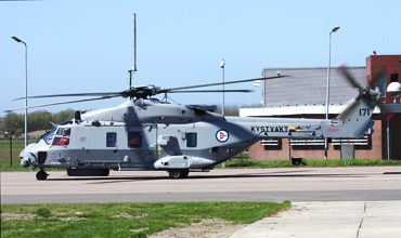
This Norwegian NH90 was visiting its Dutch colleagues and captured near the terminal, spot 2. (Martin Schmitz)

Frequencies

121.730Ground
379.750Ground / Tower
120.130Tower
372.150 / 124.230Arrival
359.100 / 123.305Spare
301.200De Kooy Operations
264.325 / 132.350Dutch Mil

Based Operators

Civil operators:
CHC Helicopters NetherlandsAW139, AW189
EASP AirDo328
Heli HollandEC155, EC175
Noordzee Helikopters VlaanderenAS365N
AW139, AW169
H145
H175
Bel AirAW139, AW189
Military operators:
DHC (7sq & 860sq)NH90-NFH

Preserved

'118/D'Actually WV828, this former Royal Navy Sea Hawk is painted in Dutch colours.
'235/K'Also a former RN example, the serial of this Wasp is really XT795. Both are preserved inside a building at the base.
220AB204, in front of new building, visible from the main gate
216/VSP-2H, former gate guard from Valkenburg has moved to an area close to the military gate.
184CS-2A, preserved on base

More Info

Den Helder AirportThe official site of Den Helder Airport
Maritiem Vliegkamp De KooyDutch National Defence pages on this base
Spotting group De KooyThe site of the Spotters Group De Kooy
Traditiekamer MLDsite of the Naval Museum on the military part of this airfield.
Scramble Message BoardDen Helder-De Kooy forum

Send Updates

Do you have updates? Or is something not listed correctly? Please let us know! You can help us and other spotters with your information.
Invalid Input
Invalid Input

0/255

Invalid Input
Invalid Input

Subscribe to Scramble

As a member you get access to all our
premium content and benefits learn more