Mildenhall (RAF)

Back to Country
ICAO Code EGUN/MHZ
Last Validated 08-2022
City Mildenhall
Position 52°21'43" 000°29'11"E
Runway(s) 10/28
Elevation 34 ft

General

RAF Mildenhall, affectionately known as 'The Hall', hardly needs an introduction really. Having been concepted as an RAF bomber base in the 1920s already, it became a USAF base after WW2 with ongoing presence of bomber and tanker units. During the Cold War it gained fame as the home of the European SR-71 detachment and it has also been a gateway for a long time, handling all sizes of transports. A modest detachment, without aircraft nowadays, has been held here by the US Navy.

Layout

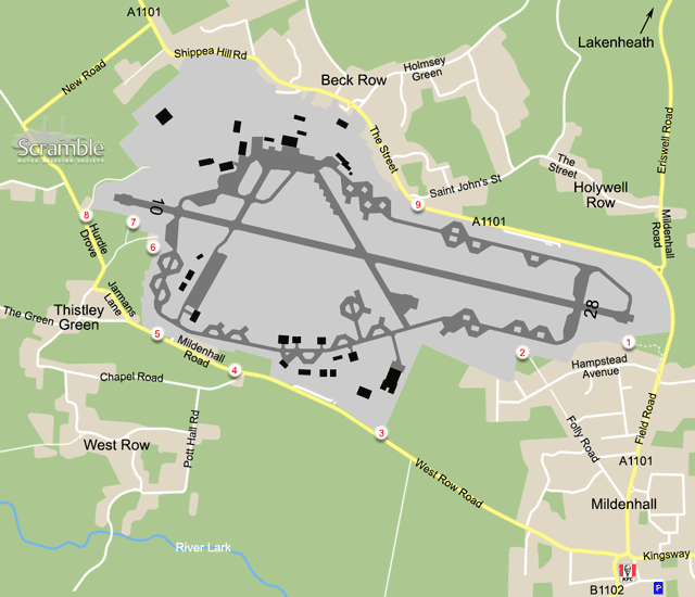
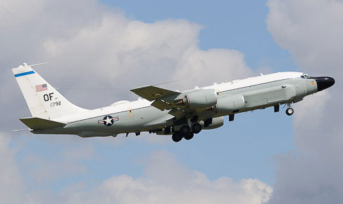
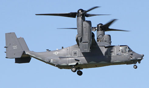
Of the three original runways, the east-west one has kept developing as the main runway with the others now in use as taxiways. There are many buildings, aprons and dispersals all over the field, making it worthwhile to circle the perimeter in order to get all the numbers. In the northwest, the cargo and passenger terminal is located, with the Ospreys being stationed west of that. To the east are the northern dispersals, mostly in use by visiting tankers. The local tankers can be found at the dispersals south of the runway, as can the various 'sneaky' C-135s on TDY. The MC-130s have their home in the southwest corner of the base. As the map shows, nearly all vantage points are at the south side. The north is largely a built-up area and the military housing quarters have been closed to the public.

Getting There

The closest dual carriageway is the A11 between Newmarket and Thetford. To get to the base, exit this at the Barton Mills roundabout (with all kinds of services) where it is already signposted. Take the A1101 into Mildenhall town, named Bury Road and then Kingsway, and keep following the signs out of town again if you are heading for spots 1, 2 or 9. Otherwise, exit the roundabout in Mildenhall town centre at the B1102 to Fordham, then immediately turn right again onto West Row Road. This leads to spots 3 and on.

Around the Airport

1The Mound

One of the two most famous Mildenhall spotting points, where all is good and nothing changes except for the aircraft. Hopefully it will stay this way, be sure not to upset anyone when spotting here (including parking the car). With winds from the west this is the best vantage point for nearly all operations, the exception being Ospreys departing from near their apron. Heavy departures may use the whole runway, lining up directly in front of you, giving great photo opportunities. The trees keep growing though so the view from the mound is partly obstructed.

To stay at this spot, follow the road signs to the base out of Mildenhall town until you are about to leave the built-up area. At the second roundabout there, past the Esso station, turn left onto Hampstead Avenue. Park somewhere along this road. Walk back towards the A1101 and follow the track to the left, and left again through the shrubberies. Follow it roughly parallel to the base fence and you will arrive at the mound.

2Folly Road

This spot is nicely close to the taxiway and dispersals along it, and offers a view of most of the northern half of the base as well. There is a 2.5m high fence with barbed wire on top though, so a ladder is needed to shoot photos over that. If this works for you, landings on 28 and take-offs from 10 can be photographed. Static shots of parked tankers are manageable through the fence. To get here, use the directions for spot 1 and then follow Hampstead Avenue for some 1600m. Turn right onto the small road between the trees. Be advised, there is no connection here with the rest of Folly Road (into town), it has been blocked with a barrier. Parking at the spot is no problem.

3South side view no.1

Following West Row Road, becoming Mildenhall Road further on, along the southern perimeter gives enough of a view on the majority of aircraft on dispersals to identify them. This includes even the visiting tankers north of the runway. Stopping is not possible everywhere, but this and the next spot may have you cover all. Spot 3 is at a farm road entrance, avoid hindering any work there of course. To get here when arriving at the airfield, follow the directions given above under... Getting There.

4South side view no.2

The second spot for the purpose described above is where Chapel Road branches off, after you passed the West Row Gate of the base. Parking briefly along the road at the junction should be OK.

567th SOS flightline

Another 600m west of spot 4, there are two disused base gates. Stop at the second one to get a very nice view on the MC-130 fightline - if it was not for the double fences. With a long ladder, unobstructed photos may be possible over them but be cautious when trying this: cars pass at high speed here.

6Southwest perimeter

Over here, the view covers both Special Operations Squadrons' areas, the runway and the dispersals in the southwest corner of the base. There is the fence again though, plus some obstructions behind it, especially near the crash gate. Walking along the fence south of the houses at the gate can be possible, depending on the state and use of the field. If so, photos are possible through the fence depending on equipment. The only advantage over spot 7 is the view on said dispersals. To get here, follow the directions for the next spot and park just past the campsite entrance, if possible.

7John's Field

Officialy named the Nook Campsite, which is dedicated to aircraft and photography, this is also widely known as John's Field after the owner. When staying here, or when visiting for the modest fee of £ 1.50 per person, you enjoy a great view over the western half of the base and the operations there. To negate the fence for photography, John offers a trailer the size of a lorry, complete with railing. When standing on it, the view on landing traffic is unobstructed. Unfortunately, base security decided to fit extra rolls of concertina on top of the fence along the trailer. To deal with that for ground-level photos, bring steps two or three high and use them on the trailer (and let us hope the competition ends there). There are lavatories as well.

To reach this spot from spot 5, turn right onto Jarmans Lane at Thistley Green. Trun right again at the T junction, this is Hurdle Drove, and then straight ahead onto the dead end Pollards Lane where Hurdle Drove bends left. The Nook Campsite will be at your left, and spot 6 just a bit further on. John's Field is open from 8 am until 8.30 pm for those who do not camp there.

8Landings runway 10

If just after the numbers or some landing shots, this is the alternative to spot 7. Just before The Willows Campsite, cars can be parked off-road and the view enjoyed. Everything on the base is seen through the fence of course. The small road along the fence is off-limits. Follow the directions for spot 7 but stay on Hurdle Drove to get here.

9North side views

Along the A1101 east of Beck Row, the serials of tankers or transports on all dispersals at the eastern half of the field can be read off. The A1101 being a rather busy, no-stopping road, the nearest option to leave the car is at the beginning of Saint John's Street in Beck Row. Theoretically, one could use the base entrance along the main road as well, but this is not advisable. After leaving the car, walk along the fence to get the numbers you want. At least the tails of large planes at the terminal will be visible as well. When arriving from the east (as described under Getting There), Saint John's Street is the first right upon entering the village.

Using a ladder, spot 2 can be a nice one for photos of departures to the east. (Erik Sleutelberg)

Spot 7 is great in many ways, and usually the best one to catch Osprey action. (Andrew Jewson)

Frequencies

337.975 / 121.800Ground
370.250 / 122.550Tower
250.300Lakenheath Departures
259.600Swanwick Approach
309.200 / 136.500Lakenheath Approach
284.425Metro
308.850 / 131.975Dispatcher
313.550Command Post
375.500ATIS

Based Operators

7th SOSCV-22B
67th SOSMC-130J
95th RSO/R/WC-135
351st ARSKC-135R/T

More Info

RAF MildenhallOfficial USAF homepage
The Nook CampsiteHomepage
Mildenhall & Lakenheath MovementsLocal enthusiast website with comprehensive logs

Other Airfields

Aberdeen-Dyce  
Barkston Heath (RAF)
Benson (RAF)  
Biggin Hill  
Birmingham
Boscombe Down (QinetiQ)
Bournemouth (Hurn)  
Bristol - Lulsgate  
Brize Norton (RAF)  
Cambridge
Cardiff (Rhoose)  
Chester (Hawarden)  
Coningsby (RAF)
Cranwell (RAF)  
Culdrose (RNAS)  
Durham Tees Valley (Teesside)  
East Midlands  
Edinburgh  
Fairford (RAF)  
Farnborough
Fife (Glenrothes)
Glasgow - Prestwick  
Glasgow Intl (Abbotsinch)
Lakenheath (RAF)  
Leeds Bradford  
Leeming (RAF)  
Leuchars  
London - City  
London - Gatwick  
London - Heathrow
London - Luton  
London - Stansted
Lossiemouth (RAF)  
Manchester (Ringway)
Marham (RAF)  
Middle Wallop  
Mildenhall (RAF)
Newcastle  
Northolt (RAF)  
Norwich  
Odiham (RAF)  
Southampton - Eastleigh  
Southend
St. Mawgan - Newquay Cornwall Airport  
Syerston (RAF)  
Valley (RAF) - Anglesey
Waddington (RAF)
Wales Low Flying Area 7
Warton
Wattisham (RAF)  
Wittering (RAF)  
Yeovilton (RNAS)  

Send Updates

Do you have updates? Or is something not listed correctly? Please let us know! You can help us and other spotters with your information.
Invalid Input
Invalid Input

0/255

Invalid Input
Invalid Input

Subscribe to Scramble

As a member you get access to all our
premium content and benefits learn more