Wales Low Flying Area 7

Back to Country
ICAO Code /
Last Validated
City Dolgellau
Position 52°42'14"N 003°50'40"W
Runway(s) (none)
Elevation

General

This airfield guide refers to the infamous "Machynlleth Loop" which is often referred as "The Loop", or the "Mac Loop" . This part of Wales is a well known place for aircraft photographers. It is part of the so called Low Flying Area 7 (LFA-7) and often used by the Royal Air Force, but it also has seen many visitors from other countries. More detail about the area can be found on the warplane.co.uk and lowfly.net websites which are an excellent resource for everyone heading towards that area.

The amount of traffic is limited and depends on how lucky you are. You might expect something like 6 to 8 hawks a day and maybe some other aircraft from other bases.

Layout

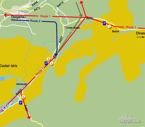
As described the A470 and A487 are the heart of the loop. Aircraft entering the loop will follow these roads flying the several routes they can take. Pilots can decide if they want to make a "full loop" which leads from Dinas in the north-east to the Tall-y-Llyn lake in the south-west and then back, following the A470 and the A487. The routes are shown in the map and explained below.

Route 1

Route 1 is the most used but has different exits which the pilots can take to discontinue the full loop. The aircraft will come from the direction of Dinas and pass the valley at viewing spot "Bwlch" and go straight on to Dolgellau. Before they reach Dolgellau, the aircraft can leave the loop towards the north in the direction of Bala. Another possibility is to continue towards Dolgellau and leave the loop there. The best option for all of us is the full loop: After coming from Dinas, the aircraft will pass through the valley at the Bwlch, bank sharp left and continue towards the Tal-Y-Llyn lake. Before reaching the lake they will pass through the very small passage at the foot of the Cadair mountain. Two vantage spots can be found here, known as Cad East and West. When reaching the lake there are two options: Either continue straight over the lake and exit the loop, or turn left in front of Corris Corner and head to Dinas again. If your are lucky they will make another round which takes about 3 minutes to complete.

Route 2

Another variant is that they come from the other side, from Dolgellau going into the loop. As the whole area has no air traffic control, it is always a bit tricky and pilots have to pay close attention if no aircraft come towards them from the direction of Bala or Dinas. When passing through the Cad, the same options exists as with Route 1; either go straight over the lake or turn left.

Route 3

This is actually the same as Route 2, but then coming from Bala

Getting There

Coming from the M5 at Birmingham take the M54 to Telford/Shrewsbury. From there take the A458 to Mallwyd, a single carriageway which goes on for about 70km. At Mallwyd take the A470 to Dolgellau. This A470 forms the heart of the loop, together with the A487.

Around the Airport

1Dinas/Bwlch

The spot which offers the best chance to take pictures is the Bwlch, pronounced as the Bulk. Most aircraft training in Wales will pass this point although there is still no guarantee as they might use Route 4 and 5 as well and exit at Tal-Y-Llyn. To get up here you need to take the A470 towards Dolgellau, pronounced as Dolgetly. After driving on a steep hill with your car, you will see a parking lot on your left hand side. Park your car here and climb over the fence towards the hill which you see a bit to your left. The path is going straight up, on the right side of of the hill. Do not go too fast, as it quite a climb and inexperienced climbers will find themselves exhausted, flat-faced in the grass. Going up here takes you 20 - 30 minutes. There are a number of viewing points up the hill:. You will see so called latches or terraces on different heights from which you can choose.

2Cad East

For the lazy people there is an option which does not involve too much climbing. This one is called Cad East. If you take the A470 you will reach the crossing with the A487 at a certain point. Here you will see an old deserted pub which is called the Cross Foxes Inn. Take the A487 south and after about a kilometre you will see a road going up on your left hand side. To enter this road you will have to go through a gate (do not forget to close it behind you). Follow this road to the end (you have to pass through another gate somewhere halfway) and you will find a small parking on your left. Be aware of the sheep walking freely here. They are quite afraid of cars passing by, but they might do stupid things when they panic. When you parked your car climb the hill on the right side of the road, This will take about 10 minutes and gives you a good overview of the A487 and the Cadair right in front of you. This spot is the best in the morning until about 14:00, as the sun will then be right in front of you. Then it is time to leave and cross the road to Cad West

3Cad West

The steep hill, you see in front of you when you are at spot 2, is known as Cad West. To get here you must follow the A487 from Dolgellau until you will reach a large parking spot on your right. Park your car here, climb the fence and follow the path which leads across the hill. You will have to traverse at the height of about 100 metres high on the hill next to the A487 in the direction of Dolgellau. Walking this way is quite tiring and it will hurt your ankles. After 15 minutes, you will reach the point at which you can go straight up. This will relieve your ankles but it is quite steep. You will reach the best spot in about 20 minutes from here. This is actually the best spot of the whole area as the aircraft will bank towards you before when they pass. Excellent shots can be made here, but be aware that this spot is only good in the afternoon. The distance to the aircraft is the closest here, so a fast reaction speed is vital.

4Corris Corner

To get here, just keep on following the A487. After passing the Minfordd Hotel on your right, the road turns sharp left. On the left side of the road there are two parking spots, a smaller one for only two cars, and a bigger one a few hundred metres down the road for about six cars. In between those parking spots there is a road going up, but only for pedestrians. Climb the fence and follow the path. It is quite steep and it takes about half an hour to get up. You will find some gates on the way. After the third gate, the road turns to the right. Here it is time to leave the path, and go straight over the fence. After about 50 meters you will find the perfect spot. Corris Corner has a view on the lake. The aircraft will come through the Cad pass at your right hand side if you are facing the Tal Y Llyn lake. Then there are two possibilities: The aircraft will go straight over the lake or bank sharp right to turn into the loop. The last option is the most favorable for you, as a photographer, as you will get a nice shot of the aircraft in a steep bank with the lake on the background. The lighting conditions are best until about 13:00, then it is time to leave.

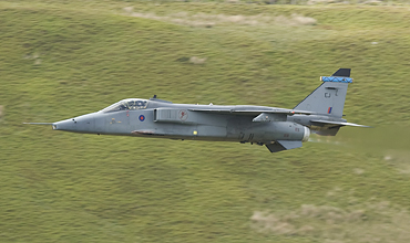
To get a good of the low flying here, start at the Bwlch

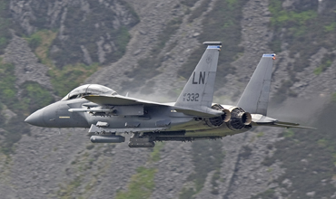
Also nice shots can be taken at Cad East (Photos: Martin Brinks)

More Info

Lowfly.netThis low flying guide contains a wealth of information about the low flying areas in the UK. A forum, maps and detailed maps are included
Warplane.co.ukWarplane.co.uk is another great website which has great pictures and a locations guide tips and tricks
franknoort.nlThe website of Frank Noort contains a trip report of four friends visiting the Loop in may 2007. Quite useful if you want to go yourselves as it explains the conditions, the experience and also contains tips and tricks.
MOD TimetableOfficial Low Flying Training Timetable

Other Airfields

Aberdeen-Dyce  
Barkston Heath (RAF)
Benson (RAF)  
Biggin Hill  
Birmingham
Boscombe Down (QinetiQ)
Bournemouth (Hurn)  
Bristol - Lulsgate  
Brize Norton (RAF)  
Cambridge
Cardiff (Rhoose)  
Chester (Hawarden)  
Coningsby (RAF)
Cranwell (RAF)  
Culdrose (RNAS)  
Durham Tees Valley (Teesside)  
East Midlands  
Edinburgh  
Fairford (RAF)  
Farnborough
Fife (Glenrothes)
Glasgow - Prestwick  
Glasgow Intl (Abbotsinch)
Lakenheath (RAF)  
Leeds Bradford  
Leeming (RAF)  
Leuchars  
London - City  
London - Gatwick  
London - Heathrow
London - Luton  
London - Stansted
Lossiemouth (RAF)  
Manchester (Ringway)
Marham (RAF)  
Middle Wallop  
Mildenhall (RAF)
Newcastle  
Northolt (RAF)  
Norwich  
Odiham (RAF)  
Southampton - Eastleigh  
Southend
St. Mawgan - Newquay Cornwall Airport  
Syerston (RAF)  
Valley (RAF) - Anglesey
Waddington (RAF)
Wales Low Flying Area 7
Warton
Wattisham (RAF)  
Wittering (RAF)  
Yeovilton (RNAS)  

Send Updates

Do you have updates? Or is something not listed correctly? Please let us know! You can help us and other spotters with your information.
Invalid Input
Invalid Input

0/255

Invalid Input
Invalid Input

Subscribe to Scramble

As a member you get access to all our
premium content and benefits learn more