Wattisham (RAF)

Back to Country
ICAO Code EGUW/
Last Validated
City Wattisham
Position 52°07'38"N 000°57'21"E
Runway(s) 05/23
Elevation 284 ft

General

The Army Air Corps is the proud heir to this former RAF Phantom base. The mainstay of the Apache fleet is currently based here. With hordes of spotters visiting Mildenhall, no one seems to take the time to venture southeast to this helicopter base. If you plan to do so, maybe this guide can help you out.

Layout

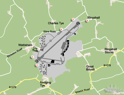
The airbase has a southwest to northeast runway orientation. The old HAS-areas of 74 and 56sq are to the north and south of the western threshold respectively. Most buildings, and more importantly the six main helicopter hangars and ramp, are on the east side of the runway.

Getting There

Wattisham is off the beaten track a bit. From the north, Bury St. Edmunds, take the A14 towards Stowmarket and Ipswich. After passing Needham Market, take exit 51 and head for the village on the B1078. Follow this road into town. You have to go left on B1113 and right again on the B1078, Barking Rd. Keep on following this to Ringshall Stocks and you will be to the southeast of the airfield.
From the southwest, Stansted for example, you can probably best take the A120 eastbound in the direction of Colchester. At Braintree, take the A131 to Sudbury. From Sudbury, follow the B1115 out of town on a northeasterly direction. This will take you to Wattisham village.

Around the Airport

1Northwest side

In Wattisham village, take Crowcroft Road to a crash gate. From this spot you can view the taxiway and runway from the north side. Early morning distant views of the ramp can be had. But especially the Apaches do not permit reading from a kilometre distance unless you have excellent lighting conditions.

2West side

To get closer to the large maintenance hangar and approach you have to follow the fence on foot.

3Southwest side approach

Should you wish to take photographs of aircraft and helicopters on approach to runway 05, you have to bring your walking shoes and continue past the threshold even further south. From the aforementioned crash gate, this is just over 1 km.

4North side ramp view

To have a go at the ramp in the afternoon, proceed from Wattisham village on Weir Road that becomes Ware road, to Charles Tye. This road follows the base perimeter fence along the old 74sq HAS area. Just after that, there is a crash gate. About 400 metres down the road, just past the road that forks off into Charles Tye, there is another crash gate with a slightly better angle and more room to park your car out of the way. Again, excellent late afternoon lighting is compulsory as well as strong bins. But you will be noticeably closer to the ramp and just opposite the 22sq hangar.

5North side approach p.m.

From spot 4 continue on Ware Rd towards Ringshall. About 500 metres east of spot 4 you will be northwest of the 23 approach and could be good for afternoon photography if you bring a ladder.

6Northeast side approach a.m.

From spot 5 again continue on Ware Rd towards Ringshall. At the T-junction make a right to Ringshall and just before the road bends left into this tiny village, make a sharp right towards the fence. About halfway down seems to be the best spot for photographing approaching aircraft with the sun in the back in the morning.

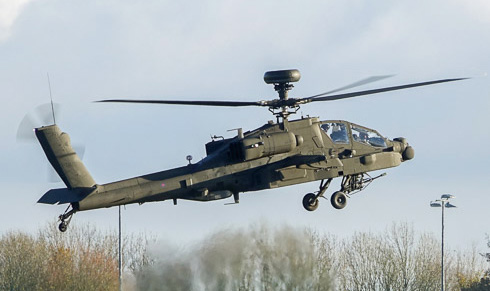
In December 2021, Tom McGhee photograped the first flight of an AAC AH-64E from spot 4.

Frequencies

358.600 / 122.100Tower
291.125 / 123.300Approach
283.575 / 123.300Director
125.800Approach / Wattisham Radio

Based Operators

Air Air CorpsApache AH1, AH-64E

Preserved

XT617Scout AH1, preserved gate
XL739Skeeter AOP12, preserved on base
XX444Gazelle AH1, preserved on base
XV139/'XV137'Scout AH1, derelct in dispersal southeast side

More Info

Wattisham Aviation SocietyLocal enthusiast society website

Other Airfields

Aberdeen-Dyce  
Barkston Heath (RAF)
Benson (RAF)  
Biggin Hill  
Birmingham
Boscombe Down (QinetiQ)
Bournemouth (Hurn)  
Bristol - Lulsgate  
Brize Norton (RAF)  
Cambridge
Cardiff (Rhoose)  
Chester (Hawarden)  
Coningsby (RAF)
Cranwell (RAF)  
Culdrose (RNAS)  
Durham Tees Valley (Teesside)  
East Midlands  
Edinburgh  
Fairford (RAF)  
Farnborough
Fife (Glenrothes)
Glasgow - Prestwick  
Glasgow Intl (Abbotsinch)
Lakenheath (RAF)  
Leeds Bradford  
Leeming (RAF)  
Leuchars  
London - City  
London - Gatwick  
London - Heathrow
London - Luton  
London - Stansted
Lossiemouth (RAF)  
Manchester (Ringway)
Marham (RAF)  
Middle Wallop  
Mildenhall (RAF)
Newcastle  
Northolt (RAF)  
Norwich  
Odiham (RAF)  
Southampton - Eastleigh  
Southend
St. Mawgan - Newquay Cornwall Airport  
Syerston (RAF)  
Valley (RAF) - Anglesey
Waddington (RAF)
Wales Low Flying Area 7
Warton
Wattisham (RAF)  
Wittering (RAF)  
Yeovilton (RNAS)  

Send Updates

Do you have updates? Or is something not listed correctly? Please let us know! You can help us and other spotters with your information.
Invalid Input
Invalid Input

0/255

Invalid Input
Invalid Input

Subscribe to Scramble

As a member you get access to all our
premium content and benefits learn more